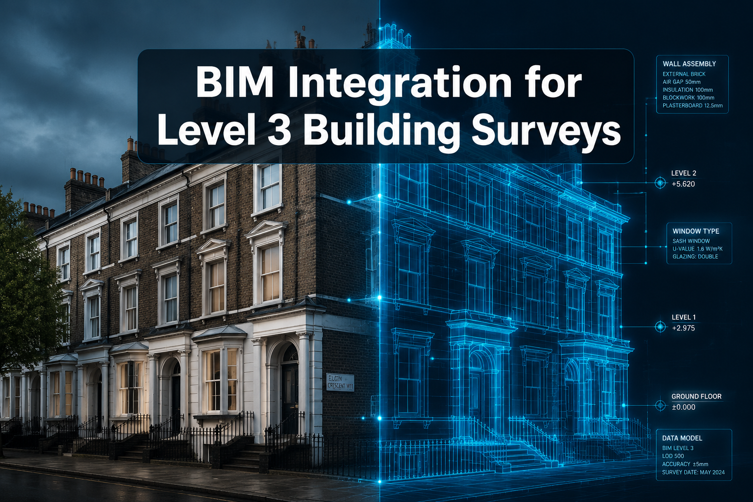
Fewer than 30% of UK surveying firms currently deploy full BIM workflows for residential and commercial Level 3 surveys — yet those that do report measurable reductions in dispute resolution time and valuation inaccuracies. As the 2026 property market continues its recovery trajectory, the case for BIM Integration for Level 3 Building Surveys: 3D Modelling Protocols for Valuation and Party Wall Assessments has never been more compelling. This guide breaks down exactly how to implement these protocols, which software to use, and what compliance checkpoints matter most.
Key Takeaways 📋
- Open BIM (Level 3) enables full interdisciplinary collaboration via a single shared model, eliminating conflicting data between surveyors, valuers, and structural engineers.
- Scan-to-BIM workflows convert laser-scan point clouds into accurate 3D models that support both defect analysis and party wall boundary definition.
- IFC and COBie data standards are non-negotiable for interoperability across valuation, legal, and construction teams.
- Party wall assessments benefit directly from 3D modelling by providing precise boundary visualisation and pre-construction condition records.
- Compliance checklists and KPI tracking are essential to measure BIM implementation success in 2026 surveying projects.
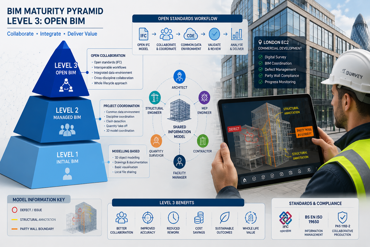
Understanding BIM Maturity Levels and Why Level 3 Matters for Surveys
Before diving into protocols, it helps to understand where Level 3 sits on the BIM maturity spectrum.
| BIM Level | Description | Collaboration Type |
|---|---|---|
| Level 0 | 2D CAD drawings only | None |
| Level 1 | Mixture of 2D/3D CAD | Limited |
| Level 2 | Federated 3D models, separate files | Managed |
| Level 3 | Single shared model (Open BIM) | Full interdisciplinary |
Open BIM (Level 3) represents full interdisciplinary collaboration using a single, centralised project model where all users — surveyors, valuers, party wall surveyors, and structural engineers — can access and modify the same model simultaneously. This removes the final layer of risk for conflicting information that plagues multi-party property assessments [4].
The CIC BIM Protocol provides the governance framework for Level 3 implementation, setting out roles, responsibilities, and data management obligations across the project team [4]. For surveying firms operating in London and the South East, aligning with this protocol is increasingly expected by lenders, local authorities, and legal teams handling party wall disputes.
💡 Pull Quote: "A single shared BIM model doesn't just improve accuracy — it creates a legally defensible audit trail that traditional 2D surveys simply cannot match."
Why Level 3 Specifically Benefits Valuation and Party Wall Work
A commercial building survey conducted at Level 3 BIM maturity produces far richer data than a standard inspection. Valuers gain access to:
- Georeferenced 3D geometry for accurate floor area calculations
- Embedded defect data linked to specific model elements
- Historical condition records that support reinstatement cost calculations
- Boundary layer visualisation critical for party wall boundary definition
For party wall matters, the ability to visualise the exact position of a shared wall in three dimensions — including its relationship to neighbouring foundations, lintels, and roof structures — transforms how surveyors prepare party wall awards and resolve disputes.
The Scan-to-BIM Protocol: Converting Survey Data into 3D Models
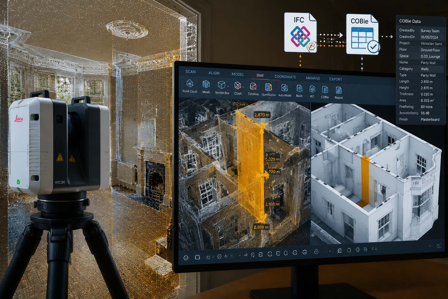
The most reliable pathway to a Level 3-ready survey model begins with scan-to-BIM methodology. This process converts physical building data captured by terrestrial laser scanners or photogrammetry drones into accurate, information-rich BIM models [2].
Step-by-Step Scan-to-BIM Workflow for Level 3 Surveys
Stage 1: Pre-Survey Planning
- Define the Level of Detail (LOD) required — typically LOD 300–400 for Level 3 building surveys
- Agree data exchange formats (IFC preferred) with all project stakeholders
- Confirm coordinate reference system and benchmark points
Stage 2: Data Capture
- Deploy terrestrial laser scanners (e.g., Leica RTC360, FARO Focus) at planned station positions
- Supplement with drone roof surveys for inaccessible areas
- Capture minimum overlap of 20–30% between scan positions for reliable registration
Stage 3: Point Cloud Processing
- Register individual scans into a unified point cloud
- Clean noise and artefacts using software such as Leica Cyclone or FARO Scene
- Alignment accuracy between survey data and 3D models is a critical quality checkpoint at this stage [3]
Stage 4: BIM Model Creation
- Import registered point cloud into Revit, ArchiCAD, or Vectorworks
- Model structural elements, party walls, and defect zones as separate BIM categories
- Attach survey metadata (inspection date, surveyor credentials, defect severity ratings)
Stage 5: Data Validation and Export
- Validate model geometry against original point cloud (tolerance: ±5mm for party wall boundaries)
- Export in IFC format for cross-platform compatibility
- Populate COBie data sheets for asset management handover [3]
Software Recommendations for 2026 🛠️
| Software | Primary Use | BIM Level 3 Ready? |
|---|---|---|
| Autodesk Revit | Model authoring | ✅ Yes |
| Navisworks Manage | Clash detection, coordination | ✅ Yes |
| Leica Cyclone Register | Point cloud registration | ✅ Yes |
| BIM 360 / ACC | Cloud collaboration | ✅ Yes |
| Civil 3D | Site and boundary modelling | ✅ Yes |
IFC and COBie data standards are critical for interoperability and must be implemented alongside upgraded tools and standard naming conventions to ensure data flows seamlessly between surveying, valuation, and legal teams [3].
BIM Integration for Level 3 Building Surveys: Protocols for Valuation Assessments
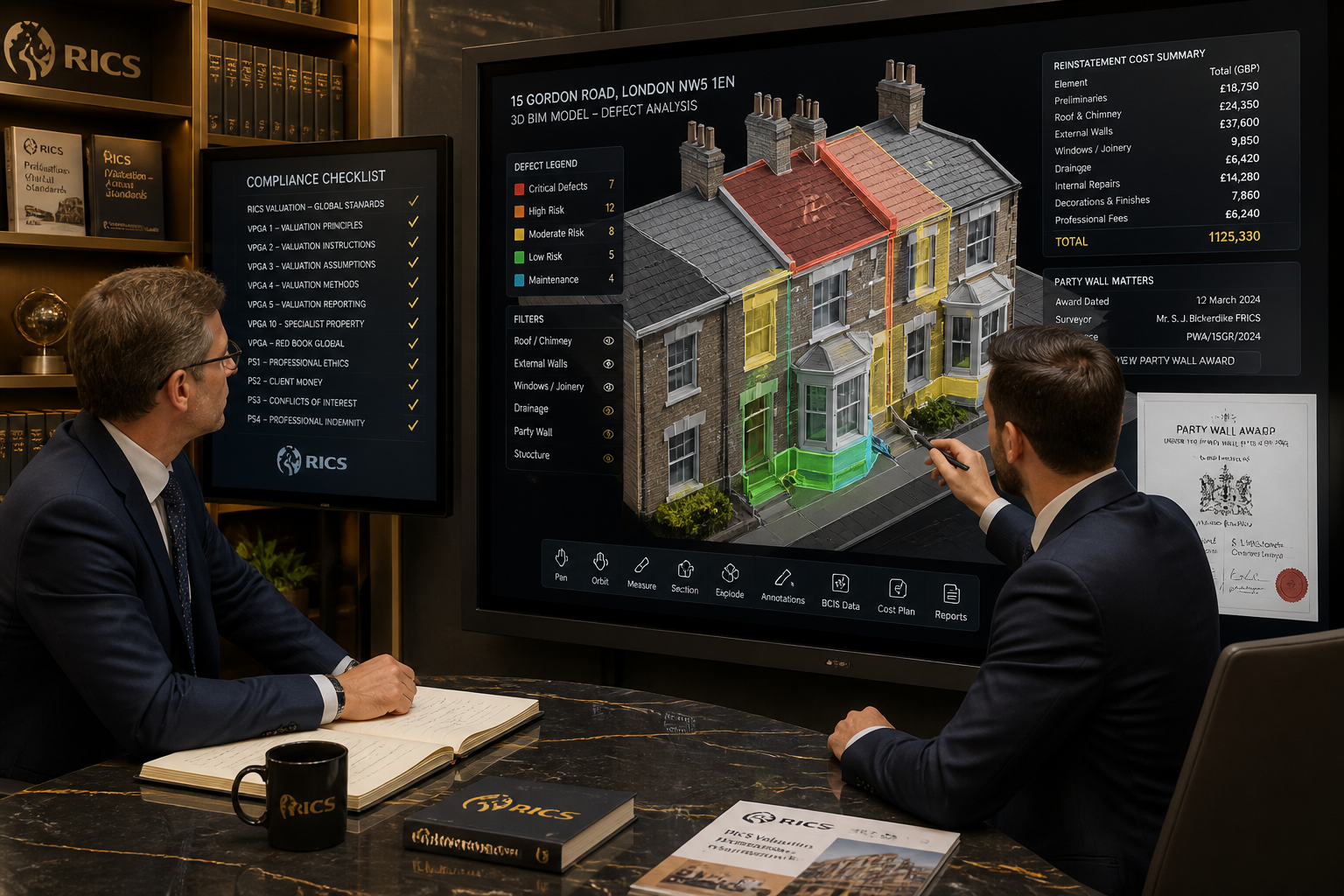
Valuation work sits at the intersection of technical accuracy and legal defensibility. BIM Integration for Level 3 Building Surveys: 3D Modelling Protocols for Valuation and Party Wall Assessments delivers specific advantages when applied to reinstatement cost valuations, dilapidation surveys, and market valuations.
3D Modelling for Reinstatement Cost Valuations
A reinstatement cost valuation requires precise measurement of gross internal area, external envelope materials, and structural complexity. A Level 3 BIM model provides:
- Automated area schedules extracted directly from the model geometry
- Material quantity take-offs linked to current BCIS cost data
- 4D and 5D integration — connecting building elements to cost databases and rebuild timelines [3]
This dramatically reduces the risk of under-insurance, which remains a significant problem across UK commercial and residential property portfolios.
Defect Analysis and Dilapidation Surveys
For dilapidation surveys, BIM models enable surveyors to:
- Tag individual defects (cracking, damp, spalling) directly to model elements
- Create colour-coded condition maps visible across the entire 3D model
- Compare current condition against a baseline model from a previous survey
- Generate automated defect schedules filtered by severity, location, or element type
💡 Pull Quote: "Colour-coded defect mapping in a Level 3 BIM model gives valuers and lenders a visual risk register that a written schedule alone cannot replicate."
Compliance Checklist: BIM Valuation Readiness ✅
Before deploying BIM for a valuation instruction, confirm the following:
- LOD specification agreed with client and lender
- IFC export capability confirmed in authoring software
- Coordinate reference system established and documented
- Survey data alignment accuracy verified (≤5mm tolerance)
- Defect classification system mapped to RICS condition ratings
- Model federated with structural engineer's model (if applicable)
- COBie data populated for all key building elements
- Data security and access permissions configured in CDE
BIM Integration for Level 3 Building Surveys: Party Wall Assessment Protocols
Party wall matters introduce a unique set of challenges: legal obligations, neighbour relationships, and the need for precise pre-construction condition records. BIM Integration for Level 3 Building Surveys: 3D Modelling Protocols for Valuation and Party Wall Assessments provides a structured framework for managing all three.
Establishing Party Wall Boundaries in 3D
The first protocol step is defining the party wall boundary layer within the BIM model with absolute precision. This is especially important for:
- Loft conversions where the party wall extends into the roof structure — see guidance on party wall considerations for loft conversions
- Excavation works near shared foundations — relevant to party wall excavation notices
- Basement extensions where underpinning affects neighbouring structures
In the BIM model, the party wall should be modelled as a separate, locked layer with:
- Precise thickness and material specification
- Georeferenced position tied to Land Registry boundary data
- Linked documentation referencing the party wall notice served on adjoining owners
Schedule of Condition Records in BIM
A party wall schedule of condition documents the pre-construction state of a neighbouring property. Integrating this into a BIM workflow means:
- Photographic evidence linked to specific model elements via QR-coded tags
- Crack monitoring data embedded as time-stamped model attributes
- Before-and-after comparison capability using model versioning
- Legal admissibility enhanced by the model's georeferenced, auditable data trail
This approach is particularly valuable when damage to property in party wall situations arise post-construction, as the BIM model provides an objective baseline.
BIM Readiness Assessment for Party Wall Instructions
2026 BIM adoption requires comprehensive readiness assessments evaluating software tools, team skill levels, file formats, and coordination processes before full implementation [3]. For party wall instructions specifically, assess:
| Assessment Area | Key Questions |
|---|---|
| Software capability | Can the authoring tool export IFC with party wall layers intact? |
| Team skills | Has the party wall surveyor received BIM coordination training? |
| Data standards | Are naming conventions aligned with the CIC BIM Protocol? |
| Legal integration | Can model outputs be attached to the party wall award document? |
| Neighbour access | Has consent been obtained to survey the adjoining property? |
KPIs for BIM-Enhanced Party Wall Projects 📊
2026 BIM implementation KPIs for party wall instructions should include [3]:
- Reduced dispute resolution time — target 25% reduction vs. traditional methods
- Faster award preparation — BIM-generated schedules vs. manual drafting
- Improved condition record accuracy — measured by post-construction claim rates
- Stakeholder satisfaction scores — from adjoining owners and building owners
BIM Trends Shaping Surveying in 2026
Several converging trends are accelerating BIM adoption across the surveying profession in 2026 [1]:
🔹 AI-assisted defect detection — machine learning models trained on point cloud data to automatically identify and classify structural defects
🔹 Digital twin integration — live sensor data feeding into BIM models for ongoing condition monitoring post-survey
🔹 Cloud-based collaboration platforms — enabling real-time model access for all parties in a party wall dispute, from surveyors to solicitors
🔹 Automated compliance checking — software that validates BIM models against building regulations and RICS standards before reports are issued
🔹 Heritage building BIM — specialist protocols for listed buildings where invasive surveys are restricted, using photogrammetry and non-destructive testing data [8]
For firms working across London and the South East, these trends represent both an opportunity and a competitive differentiator. Chartered surveyors in London who invest in BIM capability now will be better positioned to serve institutional clients, lenders, and local authorities as digital requirements tighten.
Conclusion: Actionable Next Steps for BIM-Ready Surveying in 2026
The integration of BIM into Level 3 building surveys is no longer a future aspiration — it is a present-day competitive requirement. The protocols outlined above provide a clear roadmap for surveying firms ready to make the transition.
Here are five actionable next steps to implement immediately:
- Conduct a BIM readiness audit — evaluate current software, team skills, and file format capabilities against Level 3 requirements [3]
- Adopt IFC as the standard export format — ensure all authoring software is configured for IFC output before the next major instruction
- Establish a scan-to-BIM workflow — invest in or partner with a laser scanning provider and document the step-by-step process [2]
- Integrate party wall documentation into the BIM model — link schedules of condition, notices, and award documents directly to model elements
- Set measurable KPIs — track rework rates, dispute resolution times, and client satisfaction scores quarterly [3]
The 2026 property market rewards precision, speed, and defensibility. BIM delivers all three. Whether the instruction involves a complex commercial valuation, a sensitive party wall award, or a detailed dilapidation assessment, the 3D modelling protocols described here provide the foundation for surveys that stand up to scrutiny — in the boardroom and in court.
References
[1] 5 Innovative Trends Shaping The Future Of Bim Technology – https://www.united-bim.com/5-innovative-trends-shaping-the-future-of-bim-technology/
[2] Scan To Bim Checklist Process – https://arrival3d.com/scan-to-bim-checklist-process/
[3] How To Build A Bim Transition Roadmap For Your 2026 Projects Step By Step – https://www.thecadroom.com/blog/how-to-build-a-bim-transition-roadmap-for-your-2026-projects-step-by-step/
[4] Bim Maturity Levels – https://www.mepbim.com/building-information-modeling/bim-maturity-levels/
[5] Plowman Craven Bim Specification Reference Guide – https://www.plowmancraven.co.uk/uploads/documents/brochures/plowman-craven-bim-specification-reference-guide.pdf
[8] Heag 154 Bim For Heritage – https://historicengland.org.uk/images-books/publications/bim-for-heritage/heag-154-bim-for-heritage