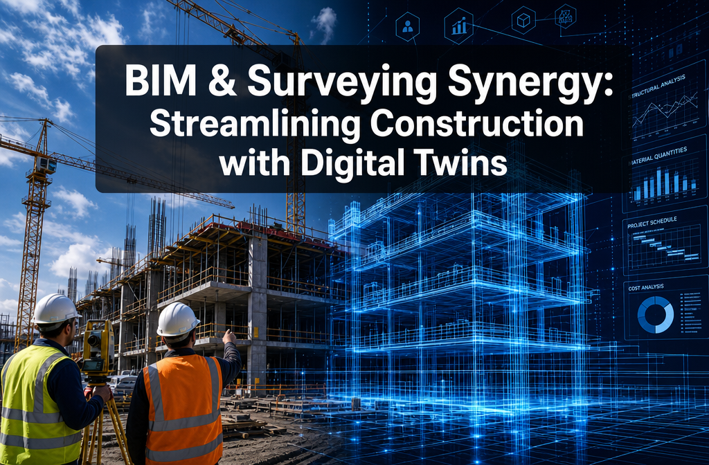
Around 65% of construction projects worldwide now use BIM workflows to some degree — yet the real productivity gains remain locked away until field survey data is continuously cycled into those models [1]. That gap between static design models and live site reality is exactly where BIM and Surveying Synergy: Streamlining Construction Projects with Digital Twins delivers its most transformative value. When surveyors feed georeferenced, survey-grade measurements directly into a Building Information Model, the result is no longer just a 3D drawing — it becomes a living, breathing digital twin that every stakeholder can trust.
This article explores how that integration works in 2026, why it matters for construction efficiency, and what practical steps teams can take to make it happen on their next project.
Key Takeaways 📌
- Digital twins are only as good as the survey data feeding them — accurate georeferencing and ongoing site measurements are non-negotiable.
- Reality capture technologies (laser scanning, drone photogrammetry, GNSS rovers) now stream data directly into Common Data Environments (CDEs) linked to BIM models.
- Error reduction and rework savings are the most immediate financial benefits, as clashes and alignment errors are caught early.
- BIM + GIS integration enables city-scale digital twins, extending value from individual buildings to entire infrastructure networks.
- Surveyors are evolving into "digital twin managers," becoming central to project controls, risk management, and asset lifecycle decisions.
From Static Models to Living Digital Twins: The Core of BIM and Surveying Synergy
For decades, BIM and surveying operated in parallel lanes. Designers built models; surveyors measured the physical world. The two rarely spoke the same language in real time. That separation is now closing fast.
"The shift is from 'as-built documentation' to 'continuous digital twin' workflows — and surveyors are the engine driving that change." [7]
What Is a Digital Twin in Construction?
A digital twin is a dynamic, data-rich virtual replica of a physical asset. Unlike a standard BIM model — which may be accurate at design stage but drift from reality as construction progresses — a digital twin is continuously updated with real-world measurements. It reflects the current state of the site at any given moment.
The key ingredients are:
| Component | Role in the Digital Twin |
|---|---|
| 🔵 BIM Model | Structured 3D geometry + asset data |
| 📡 GNSS / Total Station | Georeferencing and control network |
| 🔴 Laser Scanning | High-density point clouds of existing conditions |
| 🚁 Drone Photogrammetry | Aerial reality capture and progress mapping |
| 🌐 GIS Framework | Spatial context linking building to infrastructure |
| ☁️ Common Data Environment | Central hub for data sharing and version control |
Why Surveyors Are the Missing Link
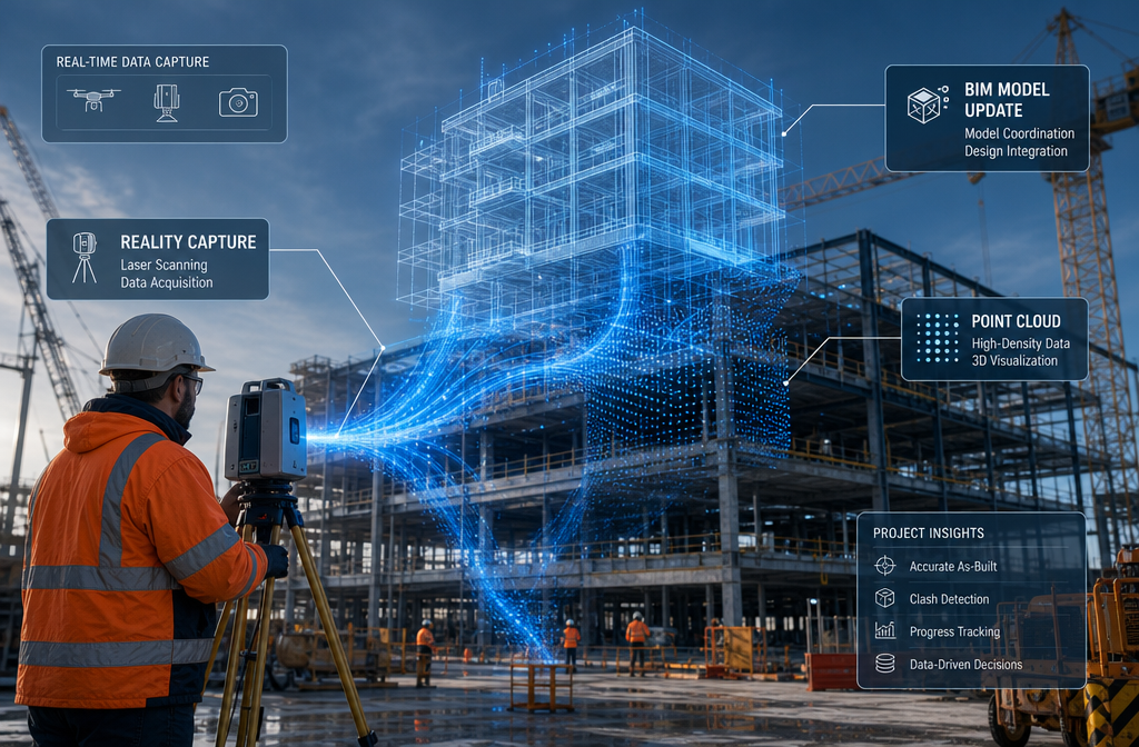
Survey professionals provide something no design tool can generate on its own: verified, real-world spatial truth. When a surveyor places a control network on site and ties it to a national coordinate system, every subsequent measurement — whether from a robotic total station, a mobile mapping system, or a UAV — inherits that accuracy. The BIM model becomes location-accurate and time-aware [8].
Without that foundation, a digital twin is simply a good-looking model that may or may not reflect what is actually built. With it, site managers can overlay design intent against current conditions on any device, in near real time [6].
For construction professionals working on complex projects, understanding the full scope of a building's condition is essential. Services such as commercial building surveys in London increasingly draw on BIM-linked data to deliver richer, more actionable condition assessments.
Reality Capture Technologies Powering BIM and Surveying Synergy: Streamlining Construction Projects with Digital Twins
The hardware and software available to surveyors in 2026 have made continuous digital twin workflows genuinely practical. Three technology families are doing the heavy lifting.
1. 🔴 Terrestrial Laser Scanning (TLS)
Terrestrial laser scanners capture millions of points per second, creating dense point clouds that represent every surface of a structure with millimetre-level accuracy. When registered to the survey control network and imported into a BIM platform, these point clouds allow:
- Deviation analysis — comparing as-built geometry against the design model
- Clash detection — identifying where installed elements conflict with planned ones
- Structural monitoring — detecting settlement or deformation over time
Professional commentary from early 2026 confirms that firms using BIM tied to laser scans and point clouds are delivering richer building condition surveys with fewer site visits and better asset-information handover at project completion [5].
For projects involving structural concerns, a residential structural engineer in London can use point-cloud data to assess deviation from design tolerances before problems become costly defects.
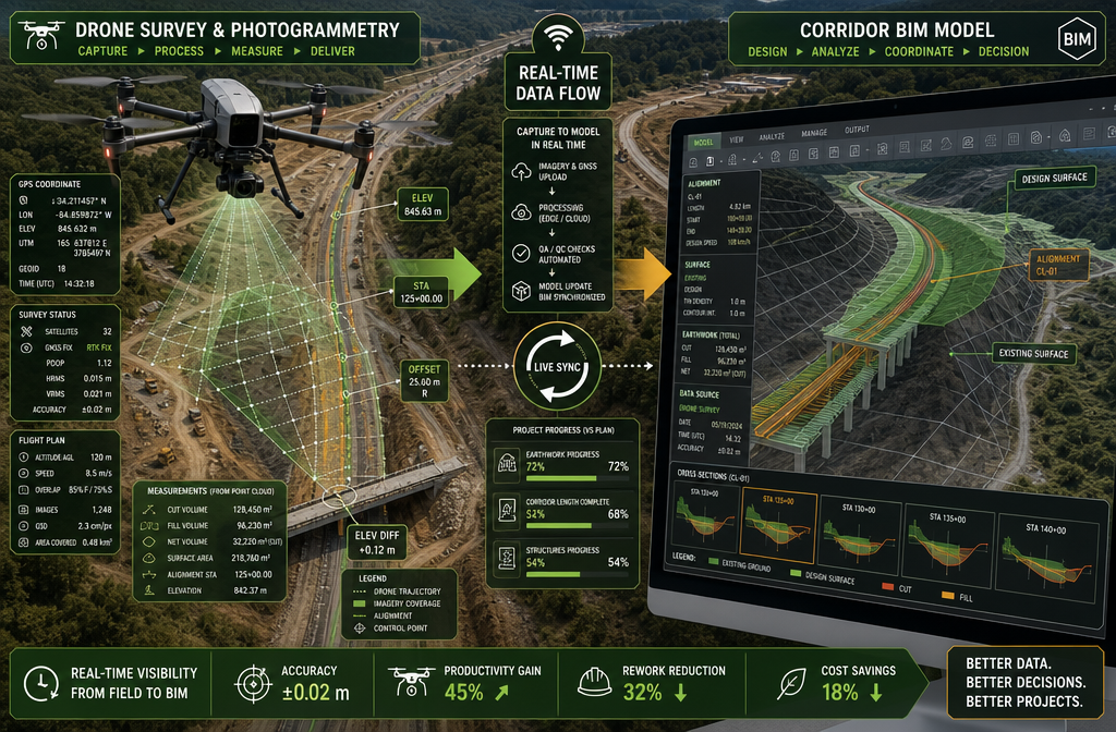
2. 🚁 UAV Photogrammetry and LiDAR
Unmanned aerial vehicles equipped with photogrammetric cameras or LiDAR sensors can survey large sites in a fraction of the time traditional methods require. In 2026, connected UAVs stream data directly into CDEs tied to BIM models, enabling near-real-time updating of digital twins [6].
Key applications include:
- Progress tracking — weekly drone flights generate updated terrain models compared against the programme
- Earthworks volumetrics — cut-and-fill calculations derived from survey-accurate surface models
- Roof and facade inspection — high-resolution imagery feeding roof survey assessments without scaffolding
3. 📡 Connected GNSS and Robotic Total Stations
Modern GNSS rovers and robotic total stations can transmit observations directly to cloud-based CDEs. This means a setting-out engineer confirming pile positions or checking slab levels is simultaneously updating the project's digital twin. Site managers can visualise current terrain and structures compared to the design model on a tablet or phone within minutes of measurements being taken [6].
The International Symposium on Automation and Robotics in Construction (ISARC) has positioned BIM-driven digital twins integrating robotic total stations and autonomous site monitoring as a core research theme for 2026, reflecting how central these technologies have become [3].
Bringing It Together: The Common Data Environment
All three technology streams converge in a Common Data Environment (CDE) — a shared, cloud-based repository where models, point clouds, survey data, and documents are managed under a single version-control framework. The CDE is the nervous system of the digital twin. Without it, data from different instruments and teams remains siloed and loses its collaborative value.
Practical Benefits: How BIM and Surveying Synergy Streamlines Construction Projects with Digital Twins

The business case for integrating survey data into BIM is compelling across every project phase. Here is where the gains are most significant.
✅ Reduced Rework and Cost Overruns
Construction rework is one of the industry's most expensive problems. Studies consistently show that a significant proportion of project costs are consumed fixing errors that could have been caught earlier. When survey data continuously updates the digital twin, alignment and grading errors are caught before concrete is poured or steelwork is fixed [6].
A practical example: a surveyor scanning a completed floor slab and comparing it to the BIM model may detect a 15mm level discrepancy in a plant room. Caught at that stage, the fix is straightforward. Discovered after mechanical and electrical services are installed, the same error can cost tens of thousands of pounds to resolve.
✅ Improved Coordination Between Disciplines
The digital twin serves as a single source of truth for architects, engineers, surveyors, contractors, and clients. When everyone interrogates the same georeferenced model:
- Structural, mechanical, and electrical clashes are resolved in the model, not on site
- Survey setting-out data confirms that built elements match coordinated positions
- Design changes are immediately visible to field teams
✅ Faster, More Reliable Progress Reporting
Traditional progress reporting relies on subjective site walks and manual measurements. With a continuously updated digital twin, quantities, completion percentages, and programme comparisons can be generated automatically from survey-captured geometry. This gives project managers and clients real-time visibility without waiting for monthly reports.
✅ Better Asset Handover and Facilities Management
The value of a digital twin does not end at practical completion. When the as-built model is accurate — because it has been continuously maintained with survey data throughout construction — the owner receives a reliable foundation for facilities management. Maintenance teams can locate assets, plan interventions, and track changes against a verified baseline [5].
This is particularly relevant for commercial property owners. A dilapidation survey in London conducted against a BIM-linked as-built record can identify departures from the original condition with far greater precision than a traditional visual inspection.
✅ Infrastructure and City-Scale Applications
The convergence of BIM, GIS, and survey-based reality capture is a prerequisite for city-scale digital twins, where individual building twins are spatially referenced in a GIS framework. This enables municipalities and infrastructure owners to run simulations — flooding, traffic modelling, utilities capacity — using accurate survey-derived geometry rather than approximate 2D data [8].
Training programmes in 2026 reflect this infrastructure focus. Courses covering BIM for road, rail, and utility projects emphasise how survey-derived terrain and alignment data — surfaces, profiles, cross-sections, and corridor assemblies — form the backbone of accurate 3D infrastructure twins [4].
Standards, Skills, and the Evolving Role of the Surveyor
Industry Standards Driving Adoption
The BIM Summit 2026, held in Stockholm in April 2026, positioned "Digital Twins & Reality Capture" and "Smart Construction & Robotics" as headline themes, with sessions focused on how survey-grade point clouds feed into BIM to create trustworthy digital twins for lifecycle decisions [2][9]. Events like this are accelerating the development of common standards and workflows that allow survey data to move seamlessly into BIM platforms.
BIM World 2026 similarly featured dedicated tracks on "Digital Twins & Asset Management" and "Reality Capture & BIM," aimed specifically at surveyors and construction engineers — a clear signal that the industry recognises surveyors as central players in digital twin delivery [7].
New Skills for Survey Professionals
The surveyor of 2026 needs a broader skill set than their counterpart of a decade ago. Key competencies now include:
- Point cloud processing — registering, cleaning, and classifying scan data
- BIM authoring and coordination — working within platforms such as Autodesk Revit, Civil 3D, or Bentley OpenRoads
- GIS integration — understanding coordinate reference systems and spatial data management
- CDE management — uploading, versioning, and issuing data within shared environments
- UAV operation and data processing — photogrammetric workflows and LiDAR processing
Looking ahead, several 2026 smart construction events and vendor roadmaps anticipate that surveyors will routinely operate as "digital twin managers" — maintaining continuous data pipelines from field sensors and robotics into BIM/GIS platforms, with AI-assisted change detection flagging discrepancies between the physical site and the design twin for rapid resolution [3][7].
Party Wall and Boundary Considerations in BIM Projects
Even in a BIM-enabled project environment, traditional surveying obligations remain important. Where construction involves shared boundaries or excavation near neighbouring properties, a party wall agreement is a legal requirement under the Party Wall etc. Act 1996. BIM models and digital twins can actually support this process — providing accurate, georeferenced records of existing conditions through a party wall schedule of condition that is far more defensible than photographs alone.
Similarly, where subsidence or ground movement is a concern on a project, a subsidence survey in London can feed monitoring data directly into the digital twin, allowing movement trends to be tracked against design tolerances over time.
Conclusion: Actionable Next Steps for 2026 and Beyond
The case for BIM and Surveying Synergy: Streamlining Construction Projects with Digital Twins is no longer theoretical. In 2026, the tools, standards, and skills exist to make continuous digital twin workflows a practical reality on projects of almost any scale.
Here are the most important steps to take right now:
-
Audit your current data workflows. Identify where survey data is collected but not integrated into the BIM model. Those gaps are where rework risk and coordination errors accumulate.
-
Invest in a Common Data Environment. Without a shared, version-controlled repository, even the best survey data loses its collaborative value. A CDE is the infrastructure that makes the digital twin possible.
-
Upskill your survey team. Point cloud processing, BIM coordination, and GIS integration are now core competencies. Training investment pays back quickly in reduced rework and faster reporting.
-
Establish georeferenced control early. Every project should begin with a survey control network tied to a national coordinate system. This single step ensures that all subsequent data — from any instrument or team — is spatially consistent.
-
Plan for handover from day one. The digital twin should be built with the end user in mind. An accurate, well-structured as-built model is a valuable asset for the owner long after the contractor has left site.
-
Engage qualified chartered surveyors. Whether the project involves complex structures, party wall obligations, or commercial dilapidations, experienced professionals bring the technical rigour that digital twin data demands. Explore the Kingston Surveyors blog for further guidance on surveying best practice across a wide range of project types.
The construction industry is moving toward a future where the physical and digital are inseparable. Surveyors who embrace that future — and the BIM platforms, reality capture tools, and data management skills it requires — will be indispensable to every project they touch. 🏗️
References
[1] Watch – https://www.youtube.com/watch?v=4LTuKhP07kU
[2] The Bim Summit By Symetri 2026 Uk – https://www.symetri.ie/news-events/events/the-bim-summit-by-symetri-2026-uk/
[3] Show 34 797 1 – https://www.academic.net/show-34-797-1.html
[4] facebook – https://www.facebook.com/groups/bimphilippines/posts/2280684679122476/
[5] Next Synergy Solutions Bim Buildingsurveying Bimtechnology Activity 7431996769720422400 Torq – https://www.linkedin.com/posts/next-synergy-solutions_bim-buildingsurveying-bimtechnology-activity-7431996769720422400-Torq
[6] The Future Of Civil Engineering Real Time Data Bim – https://www.12dsynergy.com/the-future-of-civil-engineering-real-time-data-bim/
[7] Bim World 2026 – https://www.riegl.com/en-southamerica/events/event/bim-world-2026
[8] The Synergy Of Bim And Gis In 5 Questions – https://www.gim-international.com/content/article/the-synergy-of-bim-and-gis-in-5-questions
[9] Bim Summit By Symetri – https://www.symetrigroup.com/campaigns/bim-summit-by-symetri/