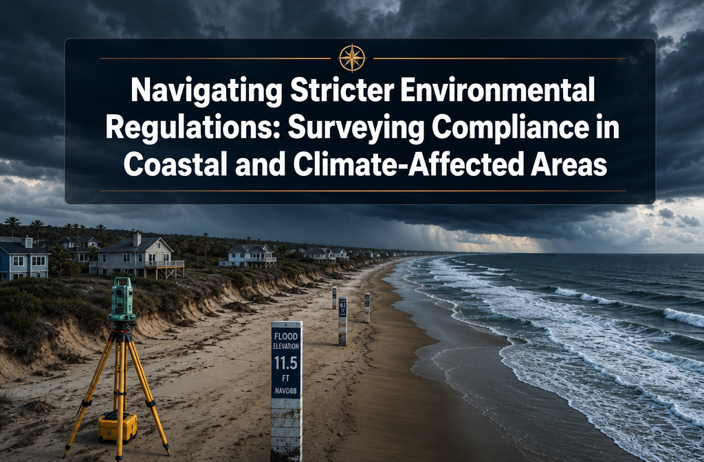
More than 40% of the world's population lives within 100 kilometres of a coastline — and in 2026, the regulatory ground beneath those communities is shifting faster than the tides. From New Jersey's sweeping new flood elevation rules to Massachusetts rewriting its waterfront licensing standards around sea-level rise projections, the era of static environmental compliance is over. For property owners, developers, and surveyors alike, navigating stricter environmental regulations: surveying compliance in coastal and climate-affected areas has become one of the most complex — and most consequential — professional challenges of this decade.
Key Takeaways 📌
- Regulatory frameworks are accelerating — new rules in 2026 (e.g., NJ REAL Rules, MA Chapter 91 revisions) are raising design flood elevations, tightening stormwater standards, and expanding wetlands protections.
- Multi-layered permitting is now the norm — coastal projects must satisfy overlapping federal, state, and local requirements simultaneously.
- Sea-level rise projections are being embedded directly into licensing and renewal decisions, meaning past approvals no longer guarantee future compliance.
- Real-time surveying technology — drones, LiDAR, and IoT sensors — is essential for accurate, defensible data collection in climate-affected zones.
- Early agency engagement and comprehensive environmental review dramatically reduce the risk of costly delays or permit refusals.
Why Climate Change Is Driving Unprecedented Demand for Coastal Surveys
The relationship between climate risk and survey demand is no longer theoretical. Insurers, lenders, and regulators are all requiring more detailed, more frequent, and more technically rigorous assessments of properties in flood-prone and coastal zones.
The Regulatory Pressure Behind the Demand
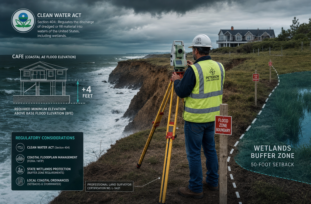
New Jersey's REAL Rules, which took effect on January 20, 2026, offer the clearest example of how dramatically the compliance landscape has changed. The Resilient Environments and Landscapes regulations overhaul coastal, flood hazard, stormwater, and wetlands standards across the state. The headline change: a new Climate Adjusted Flood Elevation (CAFE) standard, defined as the FEMA 100-year flood elevation plus 4 feet [2]. For any structure in a floodplain, this single change can alter foundation design, floor elevations, and insurance ratings overnight.
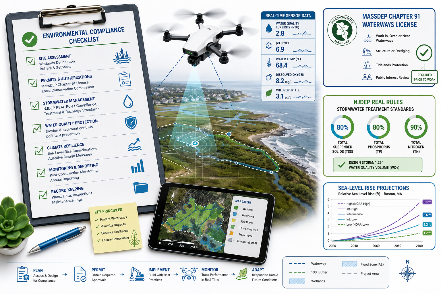
The REAL Rules also tighten stormwater requirements significantly. Reconstructed parking lots discharging to Category One (C1) waters must now achieve 95% total suspended solids removal, with a strong regulatory preference for green infrastructure best management practices (BMPs) [5]. Freshwater wetlands rules now require vernal habitat assessments and force redevelopment projects to remove impervious surfaces within 25 feet of wetland transition areas [2].
💬 "Missing the 180-day grandfathering window under New Jersey's REAL Rules can materially alter project feasibility — the difference between a viable development and a stranded asset."
Meanwhile, Massachusetts is moving on two parallel fronts. First, the state is formally regulating coastal enhanced weathering (CEW) projects — an emerging climate-response technology — under existing water and coastal laws. A March 2026 Sabin Center report found that CEW pilots on Massachusetts beaches would be treated similarly to beach nourishment under the federal Clean Water Act and Rivers and Harbors Act, while offshore projects may require a Marine Protection, Research, and Sanctuaries Act (ocean dumping) permit [1]. At the state level, these projects trigger MassDEP permits under the Public Waterfront Act (Chapter 91) and the Wetlands Protection Act [1].
Second, MassDEP has proposed revisions to its Chapter 91 Waterways regulations to explicitly require applicants to use sea-level rise projections from the Commonwealth's Resilient.mass.gov platform [6]. Renewal applications must be evaluated under current conditions and updated regulatory standards — meaning coastal licence renewals can no longer rely on old baseline conditions [3].
What This Means for Survey Professionals
These regulatory shifts create a direct, measurable increase in demand for professional surveys across several categories:
| Survey Type | Why Demand Is Rising |
|---|---|
| Flood risk & elevation surveys | CAFE standards require precise elevation data above new benchmarks |
| Wetlands delineation surveys | Expanded buffer zones and vernal habitat rules require updated mapping |
| Stormwater drainage surveys | 95% TSS removal targets require detailed drainage system assessments |
| Structural condition surveys | Licence renewals may require adaptation works, triggering condition reports |
| Boundary surveys | Coastal erosion shifts legal boundaries, creating disputes and title issues |
For property owners in coastal regions, working with chartered surveyors in Sussex or other coastal areas who understand both the technical and regulatory dimensions of these changes is no longer optional — it is a risk management necessity.
Navigating Stricter Environmental Regulations: The Multi-Layer Permitting Framework
One of the most challenging aspects of navigating stricter environmental regulations: surveying compliance in coastal and climate-affected areas is the sheer number of overlapping regulatory layers that apply to a single project. Understanding this framework is essential before a single survey peg is driven into the ground.
Federal Layer: Clean Water Act, Rivers and Harbors Act, and MPRSA
At the federal level, the Clean Water Act (CWA) Section 404 governs the discharge of dredged or fill material into waters of the United States, including wetlands. Any coastal survey project that involves ground disturbance near tidal waters or wetlands will almost certainly require a CWA Section 404 permit from the US Army Corps of Engineers.
The Rivers and Harbors Act adds another layer, requiring permits for work in or affecting navigable waters. For CEW projects and similar coastal interventions in Massachusetts, the Sabin Center report confirms these federal statutes apply directly [1].
Projects further offshore — particularly those involving the addition of materials to ocean waters — may trigger the Marine Protection, Research, and Sanctuaries Act (MPRSA), which regulates ocean dumping. The key compliance takeaway from the Sabin Center analysis is that proponents of coastal climate-response projects should expect to be treated like dredge/fill or beach nourishment operations, with multi-layered federal and state permitting [1].
State Layer: Where the Real Complexity Lives
State-level requirements frequently exceed federal standards. In Massachusetts, the Wetlands Protection Act and Chapter 91 Public Waterfront Act create a comprehensive licensing regime for any work affecting coastal waters or filled tidelands [7]. The proposed Chapter 91 revisions mean that even renewal of an existing licence becomes a trigger for climate adaptation obligations [6].
In New Jersey, the REAL Rules represent the most significant overhaul of the state's coastal and environmental regulations in decades. The rules affect:
- 🌊 Coastal zone management — revised setbacks and elevation requirements
- 🌿 Freshwater wetlands — expanded transition area requirements and new vernal habitat assessments
- 🌧️ Stormwater management — stricter treatment standards for redevelopment near C1 waters
- 🏗️ Flood hazard area rules — the CAFE standard adding 4 feet to FEMA base flood elevations [2][5]
Practical Compliance Steps for Survey Teams
Effective compliance in this environment requires a structured approach:
- Pre-application agency engagement — Contact MassDEP, NJDEP, or the relevant state agency before submitting. The Sabin Center report specifically stresses early agency engagement for CEW projects [1].
- Comprehensive environmental baseline survey — Document existing conditions thoroughly, including wetland boundaries, flood elevations, and drainage patterns.
- Use current SLR projections — In Massachusetts, use Resilient.mass.gov data. In New Jersey, design to CAFE standards [2][6].
- Track grandfathering windows — New Jersey's REAL Rules include a 180-day grandfathering period for complete applications filed within six months of January 20, 2026 [2].
- Document everything — Regulatory agencies expect comprehensive environmental review. Gaps in documentation are the most common cause of permit delays.
For complex projects requiring independent verification, an expert witness report from a qualified chartered surveyor can provide the defensible, court-ready documentation that regulators increasingly expect.
Navigating Stricter Environmental Regulations: Real-Time Tools for Compliant Data Collection
The good news for survey professionals is that technology has kept pace with regulatory demands. Real-time data collection tools are now essential equipment for any team working in coastal and climate-affected zones.
Drone Surveys: Precision at Scale 🚁
Unmanned aerial vehicles (UAVs) have transformed coastal surveying. A drone roof survey can capture centimetre-level accuracy across large coastal structures in a fraction of the time required by traditional methods — and without placing surveyors in hazardous locations. For coastal compliance work, drones offer:
- High-resolution photogrammetry for mapping erosion, flood damage, and structural change
- LiDAR integration for precise elevation data against the new CAFE benchmarks
- Thermal imaging for identifying moisture ingress and structural vulnerabilities
- Rapid repeat surveys to track change over time — critical for monitoring sea-level rise impacts on licensed structures
IoT Sensors and Real-Time Monitoring
Permanent or semi-permanent IoT sensor networks are increasingly being deployed in flood-prone coastal zones. These systems provide:
- Continuous water level monitoring against regulatory flood thresholds
- Real-time stormwater runoff data for TSS compliance tracking
- Ground movement sensors for subsidence monitoring in soft coastal soils
For properties where subsidence surveys are already a concern, integrating IoT monitoring into the compliance programme provides ongoing evidence of structural stability — data that regulators and insurers both value highly.
Boundary Surveys in Eroding Coastlines
Coastal erosion is not just a physical problem — it is a legal one. As shorelines shift, so do property boundaries, easements, and the extent of public tidal rights. Boundary surveys in London and coastal areas must now account for dynamic coastal processes, using GPS-referenced benchmarks and historical chart data to establish defensible boundary positions.
💬 "In climate-affected zones, a boundary survey is not a one-time exercise — it is an ongoing monitoring programme tied directly to regulatory compliance."
Building Condition Surveys and Reinstatement Valuations
For existing coastal structures facing licence renewal under tightened Chapter 91 or REAL Rules standards, a thorough building condition survey is the starting point for any adaptation plan. Understanding the current structural condition informs decisions about whether to elevate, modify, or replace elements of a building to meet new regulatory requirements.
Alongside condition surveys, a reinstatement cost valuation ensures that insurance coverage reflects the true cost of rebuilding to the new regulatory standards — not the old ones. In a post-CAFE, post-Chapter 91 revision world, the gap between historical reinstatement values and compliant rebuild costs can be substantial.
Building a Compliance-First Survey Programme for Coastal Properties

For property owners, developers, and public bodies managing assets in coastal and climate-affected areas, the following framework provides a practical roadmap for survey compliance in 2026 and beyond.
Step 1: Regulatory Mapping
Before any fieldwork begins, map the full regulatory landscape applicable to the property or project:
- Federal: CWA Section 404, Rivers and Harbors Act, MPRSA (if offshore)
- State: Relevant coastal, wetlands, and stormwater permits (e.g., MassDEP Chapter 91, NJDEP REAL Rules)
- Local: Municipal floodplain ordinances, coastal zone management bylaws
Step 2: Baseline Environmental Survey
Conduct a comprehensive baseline survey covering:
- Current flood elevations (referenced to CAFE or state SLR projections)
- Wetland boundaries and buffer zones
- Drainage patterns and stormwater discharge points
- Structural condition of any existing buildings or infrastructure
Step 3: Gap Analysis
Compare baseline survey data against current regulatory requirements. Identify:
- Structures or features that fall below new elevation standards
- Impervious surfaces within newly expanded wetland buffers
- Stormwater systems that do not meet updated TSS removal targets
Step 4: Adaptation Plan and Permit Applications
Develop an adaptation plan addressing identified gaps, then prepare and submit permit applications with full supporting documentation. Engage agencies early — the Sabin Center's guidance on CEW projects applies equally to conventional coastal development: early engagement reduces surprises [1].
Step 5: Ongoing Monitoring and Renewal Readiness
Given that Massachusetts is embedding SLR projections into licence renewals, compliance is not a one-time event. Establish an ongoing monitoring programme using the real-time tools described above, and schedule periodic surveys to ensure continued compliance as conditions and regulations evolve.
Working with experienced building surveyor services professionals who understand both the technical survey requirements and the regulatory context is the most effective way to manage this ongoing obligation.
Conclusion: Actionable Next Steps for 2026 and Beyond
Navigating stricter environmental regulations: surveying compliance in coastal and climate-affected areas is one of the defining professional challenges of 2026. The regulatory environment has fundamentally changed — New Jersey's CAFE standard, Massachusetts's SLR-integrated licensing, and the multi-layered permitting requirements for emerging coastal technologies all signal a permanent shift toward climate-aware compliance frameworks.
Here are the key actions to take right now:
✅ Audit existing coastal assets against new regulatory benchmarks (CAFE, Chapter 91 SLR requirements) before licence renewals are triggered.
✅ Engage regulatory agencies early — pre-application meetings with MassDEP, NJDEP, or equivalent bodies can prevent costly permit delays.
✅ Invest in real-time survey technology — drones, LiDAR, and IoT sensors provide the accurate, defensible data that regulators expect.
✅ Check grandfathering windows — New Jersey's 180-day window from January 20, 2026 may still offer options for projects in the pipeline.
✅ Commission professional surveys now — from boundary delineation to structural condition assessments, professional survey data is the foundation of every successful permit application.
✅ Plan for renewal as a compliance trigger — in Massachusetts especially, licence renewals now carry adaptation obligations. Prepare early, not reactively.
The coastline is not a static asset — and in 2026, neither is the regulatory framework that governs it. Proactive, technology-enabled, professionally supported survey compliance is the only reliable path through this rapidly evolving landscape. For expert guidance across coastal and climate-affected regions, Kingston Surveyors provides the chartered expertise needed to meet these demands with confidence.
References
[1] Regulation Of Coastal Weathering In Massachusetts A New Sabin Center Report – https://blogs.law.columbia.edu/climatechange/2026/03/31/regulation-of-coastal-weathering-in-massachusetts-a-new-sabin-center-report/
[2] Njdep 2026 Real Rules Set To Impact Construction Near Nj Coast – https://lanassociates.com/industry-insights/njdep-2026-real-rules-set-to-impact-construction-near-nj-coast/
[3] New State Rules Coastal Massachusetts Rising Seas – https://www.wbur.org/news/2023/12/22/new-state-rules-coastal-massachusetts-rising-seas
[5] Csg Law Alert Njdep Issues Final Coastal Flood Rules – https://www.csglaw.com/newsroom/csg-law-alert-njdep-issues-final-coastal-flood-rules/
[6] Massdep Proposes Changes Chapter 91 Regulations – https://www.pierceatwood.com/alerts/massdep-proposes-changes-chapter-91-regulations
[7] Environmental Permitting In Coastal Massachusetts – https://www.mass.gov/info-details/environmental-permitting-in-coastal-massachusetts