Construction projects that skip proper geospatial-to-BIM integration are 30% more likely to experience costly design clashes — clashes that could have been caught before a single foundation is poured. That single statistic explains why BIM integration for land surveyors: enhancing construction efficiency in 2026 projects has moved from a nice-to-have skill to an absolute professional requirement.
Surveyors are no longer just data collectors. In 2026, they are the first link in a digital chain that connects raw field measurements to intelligent 3D models used by architects, engineers, contractors, and facility managers. When that link is strong, projects run faster, cost less, and clash less. When it is weak, the entire model is built on shaky ground — literally and figuratively.
This guide explains how land surveyors can feed geospatial data into BIM models effectively, what tools and workflows matter most right now, and how to position surveying practices for the efficiency gains that 2026 construction projects demand. [1][2]

Key Takeaways 📌
- BIM integration is now a core surveying skill, not just a software add-on — demand for BIM-ready surveyors is growing rapidly in 2026.
- AI-driven workflows automatically classify terrain, flag anomalies, and generate surface models, cutting manual processing time dramatically.
- Digital twins built from survey data give construction teams real-time site visibility, reducing clashes and rework.
- GIS-BIM convergence is unlocking smarter large-scale infrastructure planning by combining spatial context with building-level detail.
- Cloud collaboration platforms allow near-real-time sharing of survey outputs into federated BIM environments, compressing design timelines.
Why BIM Integration for Land Surveyors Is Reshaping Construction in 2026
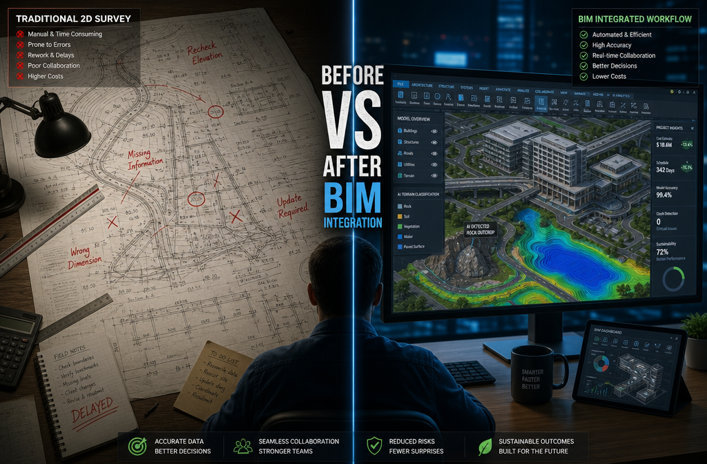
For decades, the surveyor's job ended at the edge of the site boundary drawing. Data was handed off as 2D CAD files, PDFs, or spreadsheets — and design teams would re-enter, re-interpret, and sometimes re-measure that data themselves. The result? Duplicated effort, version-control nightmares, and clash-detection failures that only surfaced during construction.
BIM changes that handoff entirely.
Building Information Modelling creates a shared, intelligent 3D environment where every discipline — survey, architecture, structural engineering, MEP, and civils — works from the same coordinated model. When surveyors supply data in BIM-ready formats, the model starts with accurate, real-world geometry. Everything built on top of it inherits that accuracy. [2]
💬 "Land surveyors are increasingly collaborating with architects, engineers, and construction professionals to integrate geospatial data into BIM models — improving project planning, reducing conflicts, and boosting construction efficiency." — Haller Blanchard [1]
The Efficiency Case in Numbers
| Traditional Workflow | BIM-Integrated Workflow |
|---|---|
| 2D drawings handed off as PDFs | IFC/RVT files fed directly into federated model |
| Manual re-entry of survey data | Automated terrain and surface model generation |
| Clash detection after design completion | Continuous clash checking during design |
| Site visits to verify as-built conditions | Real-time digital twin updated from field data |
| Siloed communication between disciplines | Cloud-based, single-source-of-truth collaboration |
The efficiency gains are not theoretical. Projects using integrated BIM workflows consistently report fewer requests for information (RFIs), shorter design cycles, and reduced on-site rework — all of which translate directly to cost and programme savings. [4]
How Surveyors Feed Geospatial Data Into BIM Models
The practical question most surveying teams face is not whether to integrate with BIM, but how to do it without disrupting existing workflows. The answer lies in understanding the data pipeline from field capture to model delivery.
Step 1: Capture Data in BIM-Compatible Formats 🎯
Modern survey instruments — total stations, GNSS receivers, terrestrial laser scanners, and UAV photogrammetry systems — can output data in formats that slot directly into BIM authoring tools. Key formats include:
- LAS/LAZ — point cloud data from lidar and laser scanning
- IFC (Industry Foundation Classes) — open BIM standard for model exchange
- LandXML — surface and alignment data for civil BIM tools like Civil 3D
- ReCap (.rcp/.rcs) — Autodesk's point cloud format for Revit integration
Choosing the right output format at the field stage eliminates conversion steps later and preserves coordinate accuracy throughout the chain. [6]
Step 2: AI-Assisted Processing 🤖
One of the biggest 2026 developments is the embedding of AI directly into survey processing workflows. Rather than a surveyor manually classifying ground points, identifying boundary markers, or building surface models from scratch, AI systems now do this automatically. [1]
These tools:
- Classify terrain (ground, vegetation, buildings, infrastructure) from raw point clouds
- Flag anomalies such as unexpected structures or subsidence indicators
- Generate preliminary surface models ready for BIM import
- Update digital twins as new field data arrives
This automation compresses the turnaround time between fieldwork and design coordination from days to hours — a critical advantage on fast-track construction programmes.
Step 3: Deliver Into the Federated BIM Model
Once processed, survey data enters the federated BIM model — the combined model where all discipline models are overlaid and coordinated. The surveyor's contribution typically includes:
- Topographic surface model — the accurate ground model on which all design sits
- Control network — the coordinate framework that ties every discipline's model to real-world positions
- Boundary and legal data — site extents, easements, and constraints
- As-built verification — checking constructed elements against design intent
For chartered surveyors in London and across the South East, delivering these datasets in BIM-ready formats is increasingly a client requirement on commercial and infrastructure projects. [7]
BIM Integration for Land Surveyors: Enhancing Construction Efficiency Through Digital Twins and GIS Convergence
Two of the most powerful developments in 2026 BIM practice for surveyors are digital twins and the convergence of GIS with BIM. Together, they extend the value of survey data far beyond the initial design stage.
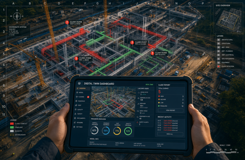
Digital Twins: The Living Model 🔄
A digital twin is a real-time, continuously updated 3D representation of a physical asset. For construction projects, the twin starts with the surveyor's site model and grows as construction progresses — incorporating as-built surveys, sensor data, and inspection records.
QeCAD describes BIM in surveying as creating "a digital twin of the physical world," capturing both geometry and richer attribute data in a single 3D model. [2] For survey departments, this means topographic surveys, control networks, and as-built checks are represented as a navigable model rather than disconnected drawings.
The practical benefits for construction efficiency include:
- 🔍 Early issue detection — design teams see real site conditions before clashes become physical problems
- 📐 Reduced setting-out errors — construction teams work from the same coordinate-accurate model
- 📋 Simplified as-built documentation — the model updates continuously rather than requiring a separate as-built survey at project end
- 🏗️ Handover-ready data — the completed twin becomes the basis for facilities management
For complex projects such as commercial building surveys in London, a digital twin approach means that condition data, structural information, and spatial measurements are all held in one queryable environment.
GIS-BIM Convergence: Scaling Up to Infrastructure 🌍
While BIM traditionally operates at the building scale, GIS (Geographic Information Systems) operates at the landscape, city, and regional scale. The convergence of these two disciplines is one of the defining trends of 2026 surveying practice. [3]
For land surveyors, this convergence means:
| GIS Capability | BIM Capability | Combined Value |
|---|---|---|
| Large-scale terrain modelling | Building-level geometry | Site context + structure detail |
| Utility and infrastructure mapping | MEP coordination | Clash detection across buried services |
| Land use and planning data | Design programme data | Regulatory compliance checking |
| Environmental constraints | Structural loads | Risk-informed design |
On large infrastructure projects — roads, rail, utilities, and mixed-use developments — the ability to bring GIS spatial context into the BIM environment gives design teams a complete picture. Surveyors who can bridge both worlds are commanding premium fees and winning more complex project commissions. [3][4]
💬 "The integration of BIM and geospatial technologies is transforming how construction professionals plan, design, and deliver large-scale infrastructure." [4]
Practical BIM Transition: What Surveying Teams Need to Do Now
Knowing the theory is one thing. Building the capability is another. Here is a structured approach for surveying practices looking to strengthen their BIM integration in 2026.
Build the Right Technology Stack 🛠️
The core tools for BIM-integrated surveying in 2026 include:
- Autodesk Civil 3D 2026 — industry-standard for civil BIM, with direct survey data import and LandXML support [6]
- Leica Cyclone or Trimble RealWorks — point cloud processing for laser scan data
- Autodesk ReCap — point cloud preparation for Revit integration
- ESRI ArcGIS Pro — GIS platform with BIM integration capabilities
- Cloud platforms (BIM 360 / ACC, Trimble Connect) — for federated model collaboration
Develop a BIM Transition Roadmap 📋
The CAD Room's guidance on BIM transition planning recommends a phased approach: [5]
- Audit current outputs — identify which deliverables can be upgraded to BIM-ready formats
- Upskill the team — prioritise Civil 3D, IFC workflows, and point cloud processing
- Pilot on a live project — choose a mid-complexity project to test the integrated workflow
- Establish data standards — agree coordinate systems, naming conventions, and LOD (Level of Detail) requirements with BIM managers
- Review and iterate — measure efficiency gains and refine the process
Address Common Integration Challenges ⚠️
| Challenge | Solution |
|---|---|
| Coordinate system mismatches | Establish shared CRS at project outset; document in BIM Execution Plan |
| Point cloud file size | Use decimated clouds for design; full resolution for as-built verification |
| Lack of BIM skills in survey team | Structured CPD, Civil 3D training, RICS BIM guidance |
| Client BIM maturity varies | Offer tiered deliverables; educate clients on efficiency value |
For structural surveys in London and similar detailed inspection work, integrating findings into a BIM environment rather than a standalone report adds measurable value for clients managing complex assets.
BIM Integration for Land Surveyors: Enhancing Construction Efficiency — Real-World Applications in 2026
The shift to BIM-integrated surveying is not happening in isolation. Across the UK construction sector, specific project types are demonstrating measurable efficiency gains.
Commercial Development 🏢
On commercial schemes, surveyors supplying BIM-ready topographic data and setting-out control networks are helping design teams eliminate coordination clashes before construction begins. Commercial property surveyors in London working on mixed-use developments are increasingly expected to deliver IFC-compliant survey models as a standard project requirement.
Residential Development 🏘️
For residential schemes, the integration of survey data into BIM helps with:
- Planning submissions — accurate 3D site context models for visualisation
- Infrastructure coordination — utilities, drainage, and road layouts clash-checked against building models
- Party wall matters — precise survey data informing party wall agreements and reducing neighbourly disputes
Infrastructure and Utilities 🚧
Large-scale infrastructure projects benefit most dramatically from GIS-BIM convergence. Survey teams delivering corridor models, utility mapping, and terrain data in BIM-compatible formats enable faster environmental impact assessments, more accurate cost planning, and smoother regulatory approvals. [3]
Dilapidations and Condition Surveys 📋
Even condition-based work is evolving. Dilapidation surveys in London that incorporate 3D scan data and deliver findings within a BIM environment give landlords and tenants a far clearer picture of terminal dilapidations liability than traditional written schedules alone.
The Skills Gap: Positioning Surveyors for BIM-Ready Demand
The demand for BIM-competent surveyors is outpacing supply. Research consistently shows that construction clients and contractors are prioritising firms that can deliver geospatial data in BIM-ready formats. [1][8]
Key competencies that differentiate BIM-integrated surveyors in 2026:
- ✅ IFC and LandXML file production — not just CAD drawings
- ✅ Point cloud processing and registration — from scan to model
- ✅ Civil 3D surface and corridor modelling — for civil BIM deliverables
- ✅ Federated model coordination — understanding how survey data fits within the wider BIM environment
- ✅ Digital twin management — updating models as construction progresses
- ✅ GIS-BIM integration — bridging spatial and building data
Surveyors operating across London and the South East — whether as chartered surveyors in Surrey or central London surveyors — who invest in these competencies now will be best placed to win the higher-value, more complex commissions that BIM-mandated projects generate.
💬 "BIM is not replacing the surveyor — it is amplifying what surveyors can deliver. The professionals who thrive are those who treat geospatial accuracy as the foundation of every BIM model." [8]
Conclusion: Actionable Next Steps for BIM-Ready Surveying in 2026
BIM integration for land surveyors: enhancing construction efficiency in 2026 projects is not a future ambition — it is a present-day competitive requirement. The surveyors and practices that master the geospatial-to-BIM pipeline are already winning more work, delivering fewer clashes, and building stronger relationships with construction clients.
Actionable Next Steps ✅
- Audit your current deliverables — identify which outputs can be upgraded to IFC, LandXML, or point cloud formats without significant additional cost.
- Invest in Civil 3D 2026 training — the software is now the standard bridge between survey data and civil BIM models.
- Establish a BIM Execution Plan template — standardise how your practice defines coordinate systems, data formats, and LOD requirements for every project.
- Partner with a BIM manager on your next project — learn the federated model environment from the inside.
- Explore GIS-BIM integration tools — particularly if your practice works on infrastructure or large-site projects.
- Document efficiency gains — measure clash reductions, RFI volumes, and programme savings to build a compelling case study for future clients.
The construction industry is building on digital foundations in 2026. Land surveyors who supply those foundations in BIM-ready formats are not just keeping pace — they are leading the way.
References
[1] Future Land Surveying 2026 – https://haller-blanchard.com/future-land-surveying-2026/
[2] How Bim Is Transforming The Future Of Surveying – https://www.qecad.com/cadblog/how-bim-is-transforming-the-future-of-surveying/
[3] Gis Bim Convergence How It Will Transform Large Scale Infrastructure Projects – https://www.teslaoutsourcingservices.com/blog/gis-bim-convergence-how-it-will-transform-large-scale-infrastructure-projects/
[4] Integrating Bim And Geospatial Technologies For Smarter Construction – https://www.geo-week.com/session/integrating-bim-and-geospatial-technologies-for-smarter-construction/
[5] How To Build A Bim Transition Roadmap For Your 2026 Projects Step By Step – https://www.thecadroom.com/blog/how-to-build-a-bim-transition-roadmap-for-your-2026-projects-step-by-step/
[6] facebook – https://www.facebook.com/kstskeacadd/posts/civil-3d-2026-for-surveyors-bim-introduction-batch-3-february-2026surveyor-scope/1238240975119705/
[7] Building Information Modeling Bim And 3d Surveying Creating Precise Digital Models For Modern Construction – https://wimbledonsurveyors.com/building-information-modeling-bim-and-3d-surveying-creating-precise-digital-models-for-modern-construction/
[8] Bim A New Model For Surveyors – https://www.gim-international.com/content/article/bim-a-new-model-for-surveyors