{"cover":"Professional landscape format (1536×1024) hero image with bold text overlay: 'Mobile 3D Mapping: Digital Replicas Without Bulky Equipment' in extra large 70pt white bold sans-serif font with dark drop shadow, centered upper third. Background shows a surveyor holding a compact handheld LiDAR scanner inside a modern London townhouse interior, with glowing blue point cloud data visualization overlaid on the walls and floor. Color palette: deep navy blue, white, electric cyan accents. Magazine cover aesthetic, editorial quality, high contrast.","content":["Landscape format (1536×1024) editorial illustration showing a side-by-side comparison: left side depicts a traditional surveying team with large tripod-mounted total station equipment in a property hallway, right side shows a single professional using a compact palm-sized 3D scanner with a glowing point cloud forming around them in real time. Clean infographic style with labels, navy and cyan color scheme, professional property surveying context, sharp detail.","Landscape format (1536×1024) detailed scene showing a grid of six compact mobile 3D scanning devices arranged on a clean white surface: FARO Orbis Premium, Panasonic @mapper tablet unit, Q3D AuraGO attached to a smartphone, GeoCue TrueView Go handheld unit, Artec Jet mounted device, and a smartphone running Scaniverse app. Each device labeled with key specs in small text overlays. Flat-lay product photography style, bright studio lighting, navy blue background, cyan accent highlights, professional editorial quality.","Landscape format (1536×1024) showing a professional chartered surveyor in a modern London residential property reviewing a completed 3D digital twin on a large tablet screen, with the actual room visible behind them matching the colorized point cloud model on screen. Warm interior lighting contrasts with cool blue digital overlay. In the background, architectural drawings and a laptop showing ArcGIS mapping software are visible on a desk. Photorealistic editorial style, professional surveying context, high detail."]
A single surveyor can now walk through a 5,000 square metre building and produce a fully georeferenced 3D model in under an hour — a task that once required a crew, a van full of equipment, and several days of processing. That shift is not a distant promise. It is the operational reality of mobile 3D mapping in 2026, and it is reshaping how properties are documented, valued, and managed across the UK and beyond.
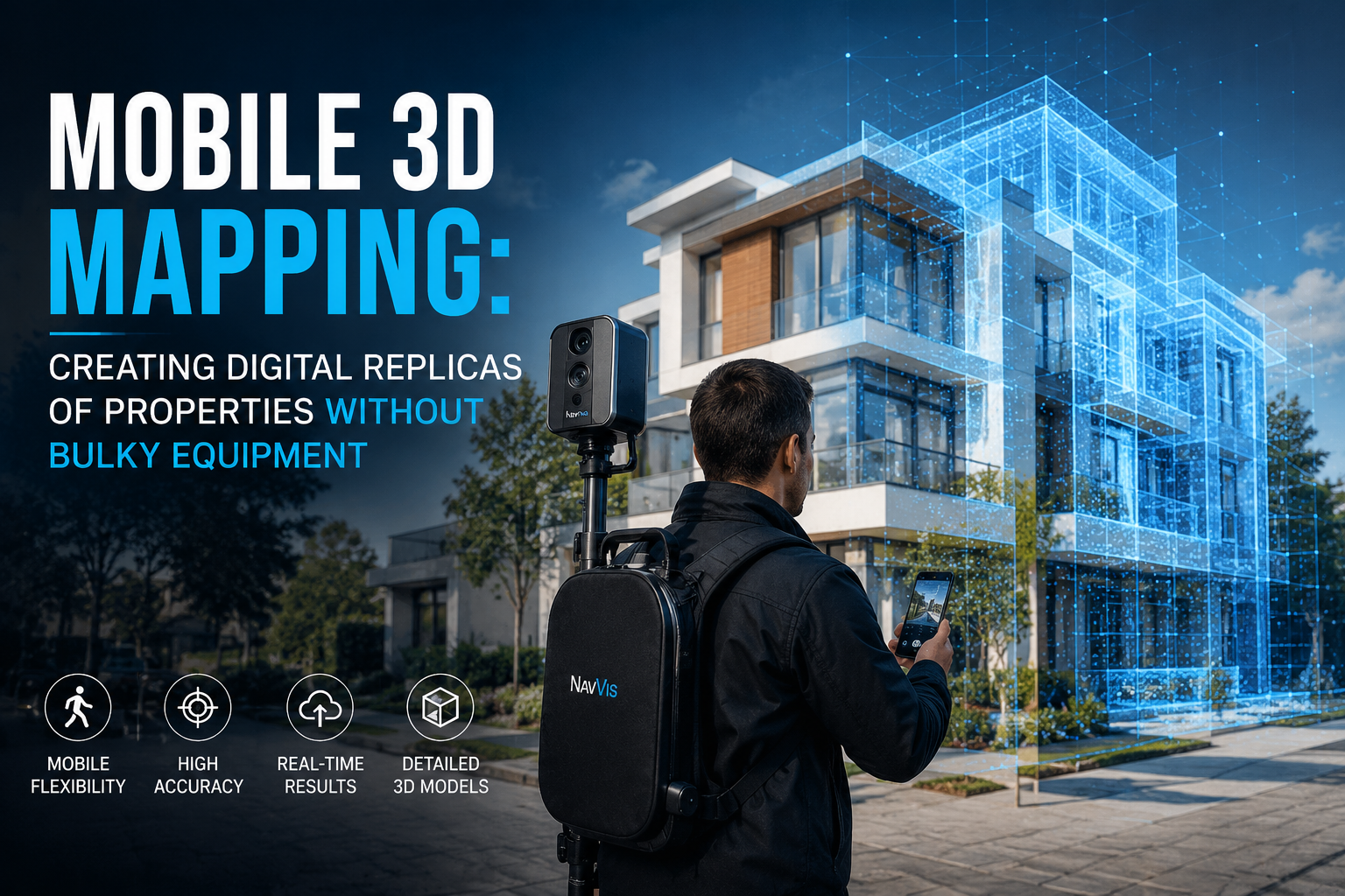
Mobile 3D Mapping: Creating Digital Replicas of Properties Without Bulky Equipment describes a new generation of portable scanning systems that combine LiDAR sensors, AI-powered processing, and smartphone-grade hardware to capture precise spatial data in the field. Whether the goal is a pre-sale property record, a structural survey, or an insurance reinstatement assessment, these tools are making high-fidelity digital replicas accessible to surveyors, architects, and property professionals who previously had neither the budget nor the logistics for traditional scanning rigs.

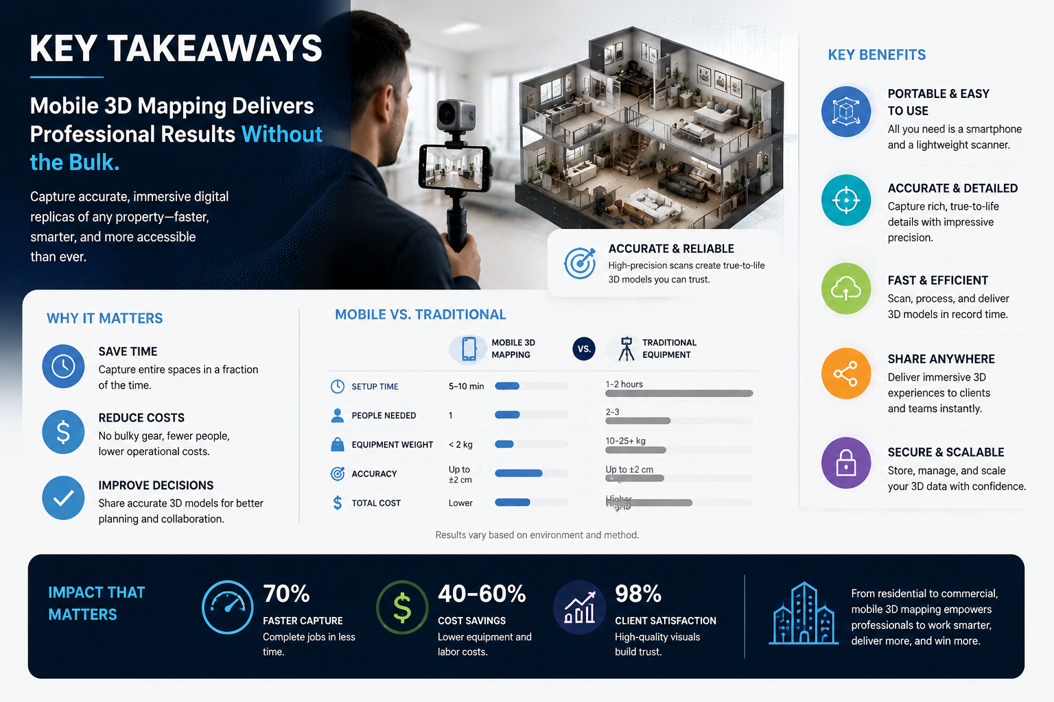
Key Takeaways
- Compact mobile 3D scanners now weigh as little as 3.6 kg and deliver millimetre-level accuracy, removing the need for heavy tripod-mounted equipment.
- Smartphone-based platforms like Scaniverse and PIX4Dcatch allow field teams to capture and sync 3D property data without specialist hardware.
- AI-driven quality control, as seen in systems like SkyeBrowse Thinking, automates error detection and reprocessing, cutting post-survey editing time significantly.
- Mobile 3D mapping has direct applications in property valuation, structural surveys, party wall documentation, and insurance reinstatement assessments.
- Surveyors in London and the South East are among the fastest adopters, given the density of complex, multi-storey properties that benefit most from rapid indoor capture.
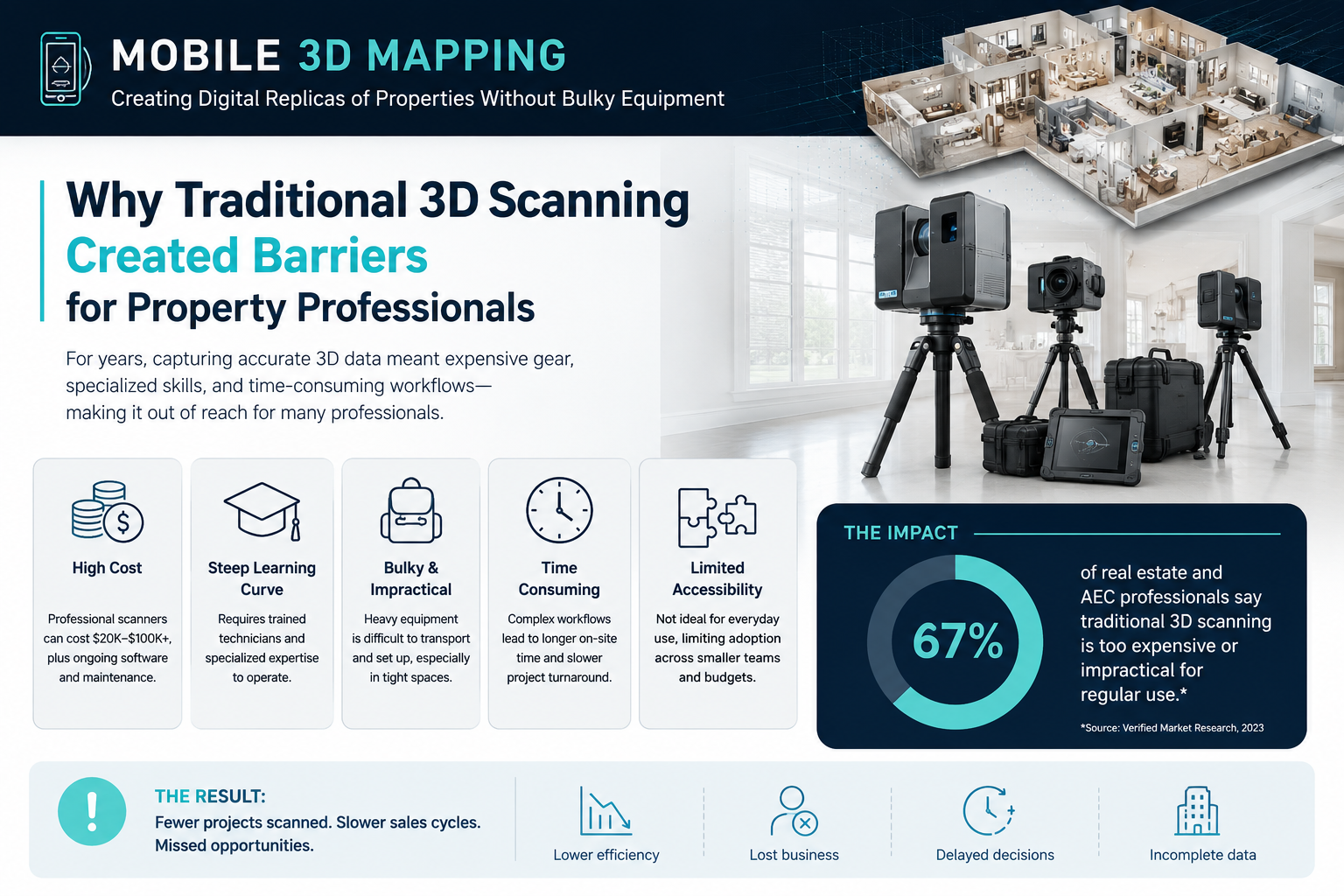
Why Traditional 3D Scanning Created Barriers for Property Professionals
For most of the last two decades, producing an accurate 3D model of a building meant bringing in a terrestrial laser scanner mounted on a heavy tripod, setting up dozens of scan positions, and spending hours in post-processing software stitching point clouds together. The hardware alone could cost upwards of £60,000, and the workflow demanded specialist operators.
These barriers meant that detailed spatial documentation was reserved for large commercial projects, heritage buildings, or high-value disputes. Residential surveyors, leasehold specialists, and property valuers were largely excluded from the technology — not because the data was irrelevant, but because the cost and complexity were prohibitive.
The result was a gap between what was technically possible and what was practically deliverable. That gap is now closing fast.
The Shift Toward Portable, Field-Ready Systems
The core change has been the convergence of three technologies: miniaturised LiDAR sensors (originally driven by the automotive industry), SLAM (Simultaneous Localisation and Mapping) algorithms that allow devices to track their own position in real time, and cloud-based AI that handles data processing remotely. Together, these advances have made it possible to build scanning systems that fit in a jacket pocket or attach to a standard smartphone.
For property surveyors, this convergence means that a structural survey in London can now include a verified spatial record of the property without adding significant time or cost to the appointment. It also means that documentation for party wall matters, boundary assessments, and reinstatement valuations can be grounded in precise, reproducible geometry rather than hand measurements and photographs alone.
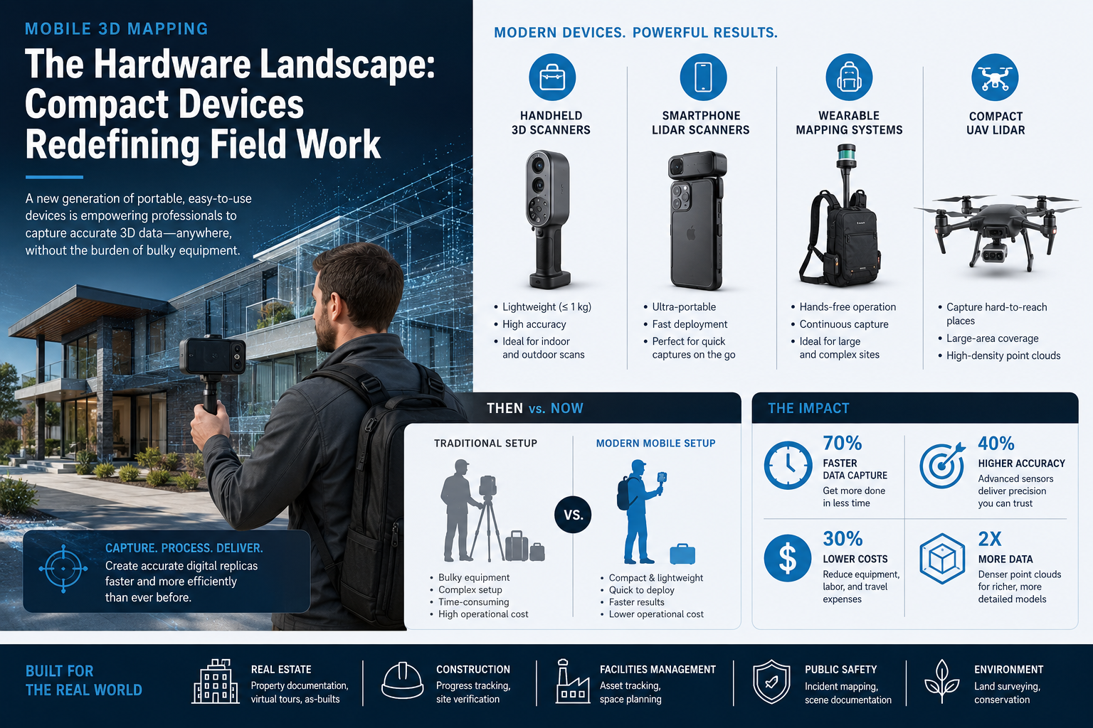
The Hardware Landscape: Compact Devices Redefining Field Work
The range of portable scanning hardware available in 2026 is broader and more capable than at any previous point. Understanding the key options helps property professionals match the right tool to the right task.
FARO Orbis Premium
FARO's Orbis Premium is one of the most talked-about compact scanners of the current cycle. Weighing just 3.6 kg including its datalogger and battery, it offers up to 5 mm precision in mobile scanning mode and up to 2 mm in stationary Flash scanning mode. [1] That dual-mode capability is particularly useful for property work: a surveyor can walk through a building quickly to capture the overall geometry, then switch to stationary mode for areas requiring greater detail, such as structural junctions or disputed boundary walls.
Panasonic @mapper
Launched in January 2026, Panasonic's @mapper is a portable indoor mapping device priced at $12,600 — positioning it as a mid-market option for professional teams. It uses a LiDAR-based laser scanner with a range of up to 60 metres and pairs with a tablet for live data visualisation. [5] The headline figure is its throughput: a 5,000 square metre building can be mapped in approximately one hour. For commercial property surveyors handling large office blocks or retail units, that speed represents a fundamental change in how site visits are structured.
GeoCue TrueView Go
Launched in August 2024, the TrueView Go from GeoCue is a handheld scanner that produces real-time georeferenced point clouds displayed live on a connected tablet. [8] It combines a GNSS Smart Antenna with high-precision LiDAR sensors, meaning the data it captures is immediately positioned in the real world — no manual registration required after the fact. For surveyors producing valuation reports in London where accurate floor areas and room dimensions are critical, this kind of immediate, verified output is highly valuable.
Q3D AuraGO
Q3D Sensing Inc.'s AuraGO is designed to attach directly to smartphones and tablets, integrating with DotProduct's Dot3D software to deliver long-range, professional-grade scanning without dedicated hardware. [4] The approach lowers the entry point significantly: a surveyor who already carries a tablet to site can add 3D capture capability for a fraction of the cost of a standalone scanner. The spatial AI layer within Dot3D handles point cloud processing, feature extraction, and model generation automatically.
Artec Jet
The Artec Jet combines SLAM-based positioning with AI-powered autonomy to capture sites and infrastructure in minutes. [7] It can be deployed by hand or mounted on mobile platforms, making it adaptable for both interior property surveys and exterior site documentation. Its survey-grade accuracy makes it suitable for applications where the data may later be used in legal or dispute contexts.
Software and Platform Developments Driving Adoption
Hardware capability alone does not explain the speed of adoption. The software platforms that process, store, and share 3D data have become equally important — and several major developments in 2026 have made the workflow significantly more accessible.
Niantic Spatial's Scaniverse and VPS 2.0
In April 2026, Niantic Spatial launched Scaniverse, a platform that allows users to capture physical spaces using smartphones or 360-degree cameras and generate detailed 3D models from the resulting data. [2] Alongside this, they introduced VPS 2.0, a visual positioning system trained on billions of images that enables precise device localisation using visual cues rather than GPS alone. For indoor environments — exactly the context where GPS is unreliable — this is a significant technical advance. A surveyor can position themselves precisely within a building using only the camera feed, with the system matching visual features against a pre-built reference map.
Esri and Pix4D Integration
In February 2026, Esri and Pix4D announced a partnership integrating the PIX4Dcatch mobile app with ArcGIS Online. [3] Field teams can now capture 3D asset data via mobile devices and sync it instantly with ArcGIS, producing high-fidelity, georeferenced 3D models that are immediately available within existing GIS workflows. For property professionals who work across multiple sites — or who need to share data with planners, architects, or local authorities — this kind of seamless integration removes a significant friction point.
SkyeBrowse Thinking
SkyeBrowse's AI-driven automation layer, launched in January 2026, analyses 3D models in real time to ensure quality standards are met, automatically reprocessing data to fix issues without requiring manual checks. [6] This addresses one of the persistent pain points in 3D scanning workflows: the time spent reviewing and correcting data after capture. By automating quality control, SkyeBrowse Thinking allows surveyors to focus on interpretation rather than data management.
Practical Applications in Property Surveying
The question most property professionals ask is not whether mobile 3D mapping is technically impressive, but whether it adds genuine value to the work they do every day. The answer, across several core practice areas, is clearly yes.
Structural Surveys and Defect Reporting
A specific defect report benefits directly from 3D spatial data because it allows the surveyor to document the precise location, extent, and geometry of a defect in a way that photographs alone cannot capture. A crack in a party wall, a deflected beam, or a subsidence-related floor slope can all be measured and recorded with millimetre accuracy using a compact mobile scanner — and the resulting model can be shared with structural engineers, insurers, or solicitors without ambiguity.
Party Wall Documentation
One of the most practically valuable applications of mobile 3D mapping in residential property work is the production of schedule of condition records for party wall matters. Before any notifiable work begins, both the building owner and the adjoining owner benefit from having a verified spatial record of the existing condition of shared walls, floors, and foundations. A party wall schedule of condition produced using a mobile 3D scanner provides a level of detail and objectivity that is difficult to challenge in any subsequent dispute.
For surveyors handling party wall disputes or acting under a party wall award in London and Surrey, the ability to produce georeferenced before-and-after comparisons is a meaningful step forward in evidence quality.
Insurance Reinstatement Valuations
Accurate floor areas and building geometry are fundamental inputs for any insurance reinstatement valuation. Errors in measured floor areas compound through the reinstatement cost calculation and can result in significant under- or over-insurance. Mobile 3D mapping removes the measurement uncertainty that has historically been a source of error in this process, producing verified dimensions that can be audited and reproduced.
Property Valuation and Sales Documentation
As the market for property valuations in London becomes more competitive and more scrutinised, the quality of supporting documentation matters. A 3D digital replica of a property provides a level of spatial evidence that supports valuation conclusions more robustly than floor plans drawn from tape measurements. It also creates a durable record that can be referenced in future transactions, lease extensions, or freehold acquisitions.
Key Considerations Before Adopting Mobile 3D Mapping
Not every project requires the same level of spatial detail, and the choice of scanning system should reflect the specific demands of the task. The table below summarises the main considerations.
| Factor | What to Consider |
|---|---|
| Accuracy requirement | Party wall and structural work typically demands 2-5 mm precision; general valuation work may accept 10-20 mm |
| Indoor vs outdoor | Some systems (e.g., TrueView Go) are optimised for outdoor georeferencing; others (e.g., Orbis Premium) excel indoors |
| Data output format | Confirm compatibility with downstream software (ArcGIS, Revit, AutoCAD, etc.) |
| Processing time | AI-automated platforms reduce post-capture work significantly |
| Cost per use | Subscription-based software models may suit low-volume users better than capital purchase |
| Operator training | Most compact systems are designed for rapid onboarding, but some practice is needed for consistent results |
A Note on Data Management
Producing a 3D model of a property generates large volumes of spatial data. Surveyors should establish clear protocols for data storage, client access, and retention periods before deploying these systems commercially. GDPR considerations apply where the data captures identifiable features of occupied residential properties.
The Outlook for Mobile 3D Mapping in UK Property Practice
The trajectory of mobile 3D mapping technology points clearly toward continued miniaturisation, lower costs, and greater automation. Systems that currently require a dedicated device are likely to be replicated by smartphone attachments within the next two to three years, and the AI processing layers are becoming more capable with each software release cycle.
For UK property professionals — particularly those working in dense urban environments like London, where complex multi-storey buildings, leasehold structures, and party wall obligations create a constant demand for precise spatial documentation — the case for adopting mobile 3D mapping is already strong. The drone roof survey services that have become standard practice for inaccessible roof inspections offer a useful precedent: technology that initially seemed specialist quickly becomes a baseline expectation once its practical value is demonstrated.
The surveyors who build competence with these tools now will be better positioned to meet client expectations as the technology becomes mainstream — and better equipped to produce the quality of evidence that complex property matters increasingly demand.
Conclusion
Mobile 3D Mapping: Creating Digital Replicas of Properties Without Bulky Equipment is no longer a niche capability reserved for large engineering firms. In 2026, compact LiDAR scanners, AI-powered processing platforms, and smartphone-integrated capture tools have made high-fidelity 3D property documentation practical and affordable for individual surveyors and small practices.
The actionable steps for property professionals looking to adopt this technology are straightforward:
- Audit current documentation workflows to identify where spatial data would add the most value — party wall schedules, structural defect reports, and reinstatement valuations are the highest-priority starting points.
- Trial a mid-market system such as the Panasonic @mapper or a smartphone-integrated option like the Q3D AuraGO before committing to higher-cost hardware.
- Evaluate software compatibility with the platforms already in use in the practice, particularly if ArcGIS, Revit, or similar tools are part of the existing workflow.
- Establish data management protocols covering storage, client access, and GDPR compliance before the first commercial deployment.
- Engage with chartered surveying networks to share experience and build collective understanding of best practice as the technology evolves.
The properties being surveyed have not changed. The tools available to document them accurately, efficiently, and without bulky equipment have changed enormously — and the professionals who recognise that shift earliest will deliver the most compelling service to their clients.
References
[1] Faro Orbis Premium – https://www.dicarlotech.com/products/3d/faro-orbis-premium?utm_source=openai
[2] From Pokemon Go To Physical Ai Niantic Spatial Unveils Its Global 3d Mapping Platform – https://www.geekwire.com/2026/from-pokemon-go-to-physical-ai-niantic-spatial-unveils-its-global-3d-mapping-platform/?utm_source=openai
[3] Ar News Esri Pix4d Terrestrial Mapping Arcgis – https://www.auganix.org/ar-news-esri-pix4d-terrestrial-mapping-arcgis/?utm_source=openai
[4] Q3d Aurago Pocket Sized Long Range Scanner – https://lidarnews.com/q3d-aurago-pocket-sized-long-range-scanner/?utm_source=openai
[5] Panasonic Launches 12 6k Lidar Scanner – https://aecmag.com/reality-capture-modelling/panasonic-launches-12-6k-lidar-scanner/?utm_source=openai
[6] Skyebrowse Ai Drone Mapping Update – https://dronedj.com/2026/01/28/skyebrowse-ai-drone-mapping-update/?utm_source=openai
[7] Artec Jet – https://www.rapidscan3d.com/products/artec-jet?utm_source=openai
[8] Geocue Launches Trueview Go Handheld 3d Mapping Scanner – https://www.equipmentworld.com/technology/article/15680893/geocue-launches-trueview-go-handheld-3d-mapping-scanner?utm_source=openai