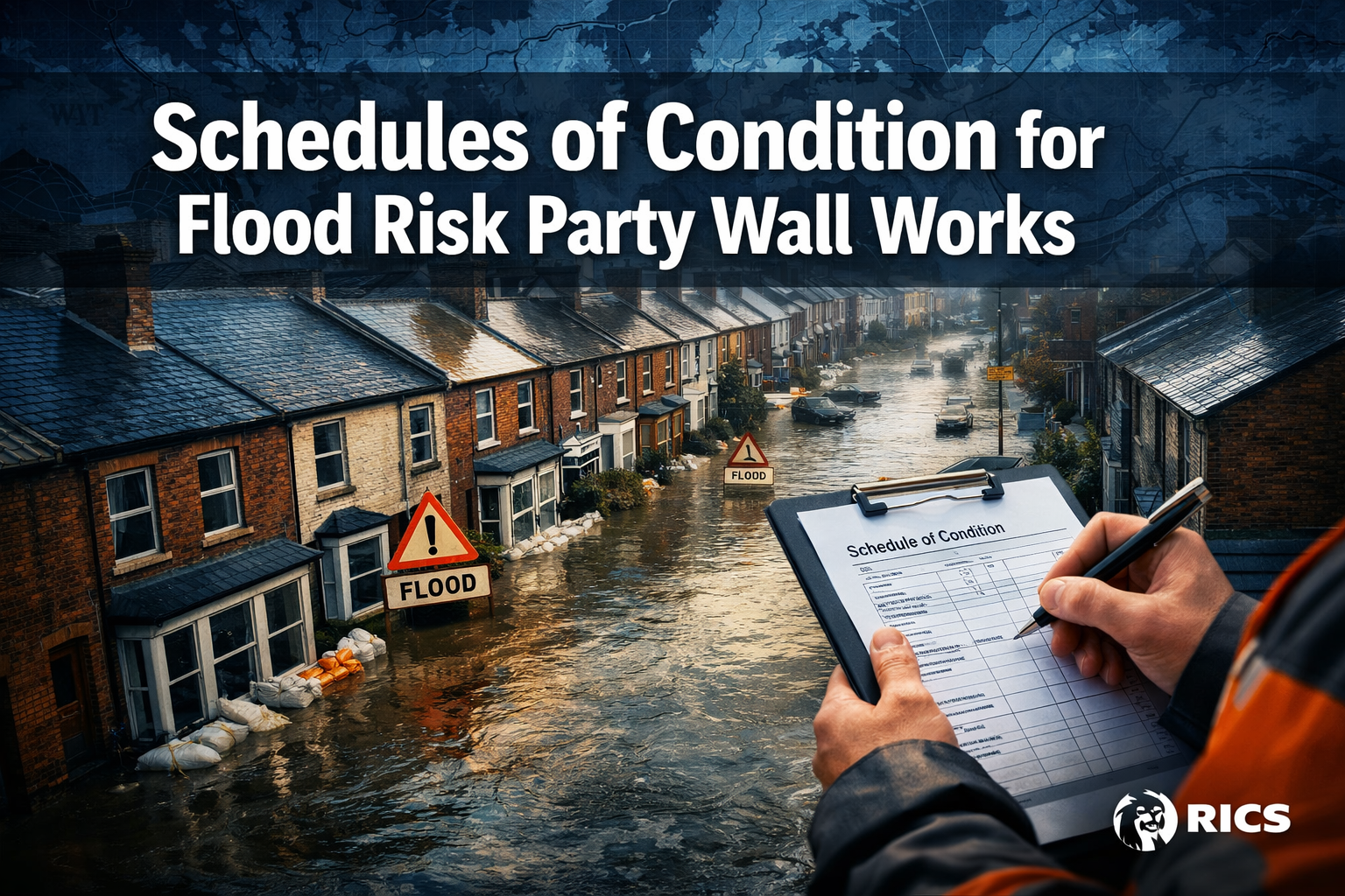
Over 5.2 million properties in England alone sit within flood-risk zones — and a significant proportion of those share party walls with neighbouring buildings. When construction work begins on a flood-prone property, the stakes for both the building owner and the adjoining owner are dramatically higher than on dry ground. Schedules of Condition for Flood Risk Party Wall Works: Integrating EA Maps into 2026 RICS Assessments represent one of the most important — and most frequently overlooked — protective tools available to both parties.
This guide offers practical templates, best practices, and a clear framework for baseline documentation in flood-prone areas, helping property owners and surveyors protect against post-works claims in 2026 and beyond.
Key Takeaways 📋
- Flood risk amplifies liability in party wall disputes — pre-existing water damage must be documented precisely before any notifiable works begin.
- Environment Agency (EA) flood maps are now an essential reference tool when preparing Schedules of Condition in flood-risk zones.
- 2026 RICS guidance places greater emphasis on environmental context, including flood exposure, within party wall assessments.
- A properly structured Schedule of Condition is the single most effective defence against spurious post-construction flood-damage claims.
- Integrating EA mapping data into your Schedule of Condition is not just best practice — in many cases, it is becoming a professional expectation.
Why Flood Risk Changes Everything in Party Wall Assessments
The standard party wall process is well established under the Party Wall etc. Act 1996. A building owner serves notice, the adjoining owner responds, and — where there is dissent or no response — surveyors are appointed to produce a Party Wall Award [5]. For a comprehensive overview of how this process works, see this guide to party wall matters.
But in flood-risk areas, the process carries a layer of complexity that standard procedures simply do not address. Here is why:
- Pre-existing flood damage to walls, foundations, and finishes is common and easily confused with construction-related damage.
- Hydrostatic pressure from waterlogged ground can cause cracking, movement, and damp that mimics the effects of nearby excavation or piling.
- Post-works claims in flood-risk zones are disproportionately common because neighbours may attribute long-standing flood damage to recent construction.
- Insurers and courts require clear baseline evidence to distinguish between flood-related deterioration and construction-caused damage.
💡 Pull Quote: "Without a robust Schedule of Condition that accounts for flood exposure, even the most careful building owner can face a six-figure dispute over damage they did not cause."
The 2026 RICS compliance framework for party wall surveys explicitly recognises the growing importance of environmental context — including flood risk — in pre-works assessments [1]. This shift reflects both the increasing frequency of flood events across the UK and the rising volume of post-construction disputes in riverside and low-lying urban areas.
Understanding EA Flood Maps and Their Role in 2026 RICS Assessments
The Environment Agency's Flood Map for Planning divides land into three flood zones:
| Flood Zone | Description | Annual Probability of Flooding |
|---|---|---|
| Zone 1 | Low probability | Less than 0.1% (1 in 1,000) |
| Zone 2 | Medium probability | 0.1%–1% (1 in 1,000 to 1 in 100) |
| Zone 3a | High probability | Greater than 1% (1 in 100) |
| Zone 3b | Functional floodplain | Regularly floods |
For party wall surveyors preparing Schedules of Condition for Flood Risk Party Wall Works, the EA map is the starting point — not an afterthought. Knowing which flood zone a property sits in determines:
- The depth and scope of the baseline survey — Zone 3 properties require more extensive photographic and measured documentation.
- The specific indicators to look for — tide marks, efflorescence, salt crystallisation, and cracked render at low levels.
- The language used in the Schedule — explicitly noting flood exposure protects both surveyors and their clients.
- The risk weighting applied to any post-works claim — a documented Zone 3a location makes it far harder for a neighbour to claim that new cracking was caused solely by construction.
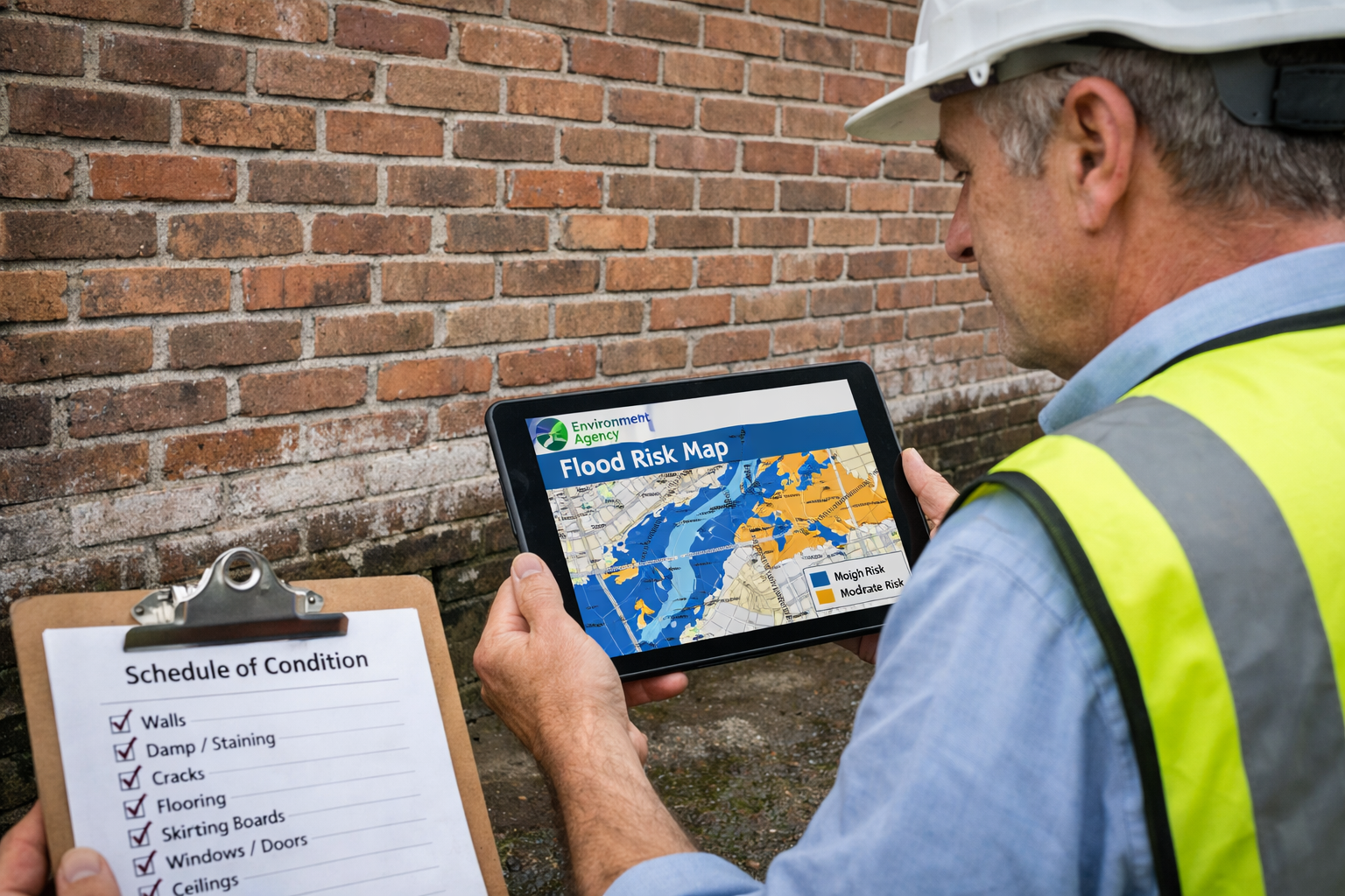
How to Access and Interpret EA Maps for Party Wall Purposes
Surveyors should access the EA's Check your long-term flood risk service and the Flood Map for Planning portal before attending any pre-works inspection in a potentially flood-affected area. Key steps include:
- ✅ Record the flood zone designation for the subject property and the adjoining property.
- ✅ Check for any Surface Water Flood Risk data, which is separate from river/sea flooding and often affects urban terraced properties.
- ✅ Note any historic flood outlines — areas that have flooded in the past but may not currently sit within a formal flood zone.
- ✅ Download and print (or embed digitally) the relevant map extract to append to the Schedule of Condition.
Templates and Best Practices for Schedules of Condition in Flood-Risk Areas
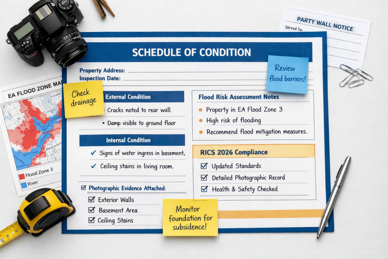
A Schedule of Condition is a detailed record of the condition of an adjoining owner's property immediately before construction works begin [3][4]. In flood-risk areas, this document must go significantly further than a standard schedule. The following framework reflects best practice aligned with Schedules of Condition for Flood Risk Party Wall Works: Integrating EA Maps into 2026 RICS Assessments.
Core Template Structure
Section 1: Property Identification and Flood Risk Context
- Full address of both the building owner's and adjoining owner's properties
- EA Flood Zone designation (with map extract appended)
- Surface water flood risk rating
- Historic flood events (if known or evidenced)
- Date and time of inspection
Section 2: External Condition — Flood-Sensitive Elements
- Ground floor external walls: note any tide marks, staining, or erosion at low level
- Pointing and mortar condition: document any existing friable or missing mortar
- Air bricks and ventilation: record locations and condition
- Drainage channels and gullies: photograph and describe condition
- Boundary walls and gates: note any lean, cracking, or settlement
Section 3: Internal Condition — Ground Floor and Basement
- Floor finishes: record any lifting, buckling, or staining consistent with past flooding
- Skirting boards and wall finishes: note tide marks, damp staining, or blown plaster
- Structural walls: document any existing cracks with crack gauges (record width, length, and orientation)
- Basement or cellar (if present): full photographic record of all surfaces
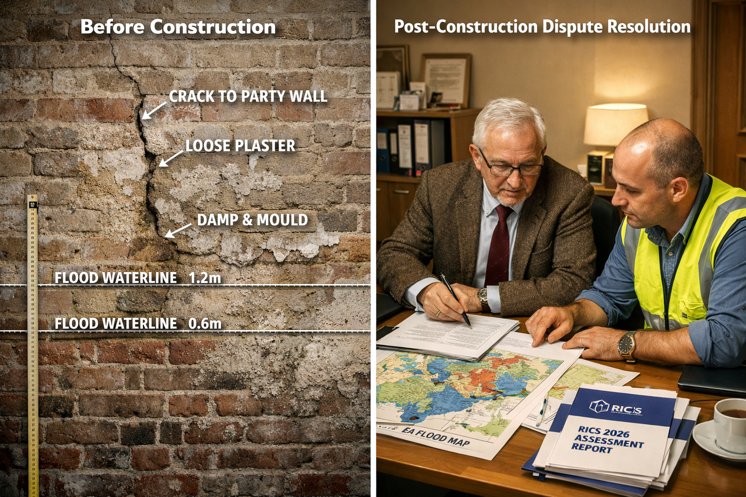
Section 4: Structural Crack Documentation
For each crack identified:
| Reference | Location | Width (mm) | Length (mm) | Orientation | Likely Cause |
|---|---|---|---|---|---|
| C1 | Front elevation, low level | 2.5 | 450 | Horizontal | Possible flood-related movement |
| C2 | Internal party wall, ground floor | 1.0 | 200 | Diagonal | Settlement — pre-existing |
⚠️ Best Practice Note: Always use crack monitoring studs or tell-tales on any crack wider than 1mm before works commence. Photograph the gauge at the time of installation.
Section 5: Photographic Record
- Minimum 50–80 photographs for a standard terraced property in a flood zone
- All photographs geo-tagged and time-stamped
- Key flood indicators photographed at close range with a scale rule
- Overall elevation shots for context
Section 6: EA Map Appendix
- Printed or digital extract of the EA Flood Map for Planning
- Surface water flood risk map extract
- Any relevant Environment Agency correspondence or flood history records
Additional Best Practices for Flood-Risk Schedules
Use video walkthroughs. A short video survey of the property, narrated by the surveyor, provides compelling evidence that photographs alone cannot match. Many surveyors now append video files to digital Schedules of Condition.
Record damp meter readings. In flood-risk properties, taking and recording damp meter readings at multiple points along ground-floor walls creates a quantitative baseline that is very difficult to dispute later.
Note the season and recent weather. A property surveyed after a dry summer will present differently from one surveyed after winter flooding. Record recent rainfall data and note whether the ground appears waterlogged.
Agree the Schedule with the adjoining owner. Under the Party Wall etc. Act framework, both parties should ideally acknowledge the Schedule of Condition. This does not mean they must sign it, but a record of it being shared is valuable. For more on how the party wall agreement process works, see this guide to party wall agreements.
Integrating EA Maps into 2026 RICS Assessments: Compliance and Professional Standards
The RICS Party Wall Legislation and Procedure guidance (7th Edition) sets out the professional framework within which party wall surveyors operate [5]. While the 7th Edition predates the current 2026 assessment cycle, the principles it establishes — including the need for thorough pre-works documentation — are directly applicable to flood-risk scenarios.
In 2026, RICS assessments place increasing weight on environmental competence [6]. Surveyors are expected to demonstrate awareness of site-specific risks, and flood exposure is explicitly part of that landscape. Failing to account for a property's flood zone status in a Schedule of Condition is increasingly viewed as a professional shortcoming, not merely an omission.
The 3-Metre Rule and Flood-Risk Excavations
One of the most common triggers for party wall procedures in flood-risk areas is basement excavation or underpinning — works that frequently fall within the scope of the Party Wall Act 3-metre rule. In flood-prone ground, excavation carries heightened risk of:
- Ground heave caused by changes in hydrostatic pressure
- Settlement of the adjoining property's foundations
- Water ingress into the excavation affecting neighbouring structures
All of these risks make a flood-aware Schedule of Condition not just advisable but essential. The Schedule must document the pre-existing condition of the adjoining owner's foundations and lower walls with particular care.
Protecting Against Post-Works Claims 🛡️
The most common post-works claim in flood-risk areas follows a predictable pattern: works are completed, the following winter brings flooding, and the adjoining owner attributes newly visible damage to the construction rather than to the flood event.
A well-prepared Schedule of Condition breaks this claim at its foundation. Specifically:
- Pre-existing flood indicators documented in the Schedule (tide marks, staining, cracked render) demonstrate that damage pre-dates the works.
- EA map data appended to the Schedule confirms the property's flood exposure, contextualising any post-works deterioration.
- Damp readings and crack measurements provide quantitative evidence that any worsening of condition is consistent with flood events, not construction.
For more detail on how damage claims are handled under the party wall framework, see this resource on damage to property in party wall disputes.
The Role of the Agreed Surveyor in Flood-Risk Cases
In many party wall disputes, both parties appoint a single party wall agreed surveyor to act impartially. In flood-risk cases, the agreed surveyor carries a particular responsibility to ensure that the Schedule of Condition is genuinely comprehensive — because they are the sole professional safeguard for both parties.
An agreed surveyor in a flood-risk area should:
- Independently verify the EA flood zone status of both properties
- Ensure the Schedule explicitly references flood risk
- Recommend crack monitoring where any existing movement is noted
- Advise both parties of the limitations of the Schedule in relation to future flood events
Practical Checklist: Flood-Risk Schedule of Condition in 2026
Use this checklist before finalising any Schedule of Condition for works in a flood-risk area:
- EA Flood Zone designation confirmed and map extract appended
- Surface water flood risk checked and recorded
- Historic flood outlines reviewed
- External low-level walls fully photographed and described
- Internal ground floor and basement fully documented
- All cracks measured and recorded in tabular format
- Damp meter readings taken and recorded at multiple points
- Video walkthrough completed
- Recent weather conditions noted
- Schedule shared with adjoining owner before works commence
- Crack monitoring installed on any crack wider than 1mm
For properties in London and the South East — where many flood-risk party wall cases arise — chartered surveyors in London with specific experience in flood-risk assessments are well placed to prepare these documents to the required standard.
Surveyors handling cases in areas such as Richmond, Twickenham, or Kingston — all of which include significant stretches of Thames floodplain — should be particularly familiar with this integrated approach. Chartered surveyors in Richmond and chartered surveyors in Twickenham regularly encounter flood-risk party wall cases and are well versed in EA map integration.
Conclusion: Actionable Next Steps for 2026
Schedules of Condition for Flood Risk Party Wall Works: Integrating EA Maps into 2026 RICS Assessments is no longer a niche specialism — it is a mainstream professional requirement for any surveyor working in flood-affected areas of England and Wales.
The integration of EA mapping data into pre-works documentation is the single most effective step that building owners, adjoining owners, and their surveyors can take to protect against post-construction claims. The templates and best practices outlined in this guide provide a solid foundation for that protection.
Actionable Next Steps ✅
- Before serving a party wall notice, check the EA Flood Map for Planning for both properties and record the flood zone designation.
- Commission a flood-aware Schedule of Condition from a RICS-regulated surveyor with environmental risk experience — not a standard template survey.
- Install crack monitoring on any pre-existing cracks before works begin, and photograph gauges at regular intervals.
- Append EA map extracts to the Schedule of Condition as a formal appendix, not an informal note.
- Share the completed Schedule with the adjoining owner before works commence and retain a time-stamped copy.
- Revisit the Schedule after any flood event during the construction period and update the record accordingly.
For any questions about the party wall process, including flood-risk scenarios, the party wall act questions resource provides a comprehensive starting point.
References
[1] Party Wall Surveys And Neighbour Disputes During 2026s Construction Uptick Rics Compliance Framework – https://nottinghillsurveyors.com/blog/party-wall-surveys-and-neighbour-disputes-during-2026s-construction-uptick-rics-compliance-framework
[2] Reading Your Rics Survey Report What To Look For – https://www.adamjoseph.co.uk/reading-your-rics-survey-report-what-to-look-for
[3] Schedule Of Condition – https://www.ansteyhorne.co.uk/news/schedule-of-condition
[4] Party Wall Schedule Of Condition – https://hardingsurveyors.co.uk/party-wall-matters/party-wall-schedule-of-condition
[5] Jan 22 Party Wall Legislation And Procedure 7th Edition – https://www.rics.org/content/dam/ricsglobal/documents/standards/jan_22_party_wall_legislation_and_procedure_7th_edition.pdf
[6] Session One 2026 Uki Assessments Are Now Underway – https://www.rics.org/news-insights/session-one-2026-uki-assessments-are-now-underway
[7] Party Wall Surveys For 5g Mast Installations Rics Protocols Amid 2026 Telecom Infrastructure Expansion – https://nottinghillsurveyors.com/blog/party-wall-surveys-for-5g-mast-installations-rics-protocols-amid-2026-telecom-infrastructure-expansion