Fewer than one in five UK homebuyers commission a full building survey before exchange, yet the physical evidence needed to protect their investment increasingly begins not at the front door, but hundreds of metres above it. Satellite imagery in property surveying, and the wider discipline of remote sensing, have transformed the way chartered surveyors gather preliminary evidence for boundary assessment, damp screening, and defect identification. This article explains precisely where that remote evidence adds value, where it misleads, and how responsible UK practitioners combine it with traditional site inspection and documentary records.
Key Takeaways
- Satellite and aerial imagery provide useful contextual evidence for boundary, drainage, and vegetation issues, but they cannot establish legal boundaries or confirm active damp without on-site verification.
- RICS Earth Observation and Aerial Surveys guidance (6th edition) sets the professional standard for remote sensing in UK surveying practice.
- Thermal drone surveys are the most practical remote tool for damp and heat-loss screening at property scale; satellite imagery is better suited to portfolio and boundary-context work.
- Remote evidence must always be treated as part of an evidence set, never as a sole determinant of condition or title.
- Combining remote data with a qualified site inspection produces the most defensible, accurate survey outcome for buyers, lenders, and legal advisers.
What Remote Sensing Actually Means for UK Property Surveyors
The term "remote sensing" covers a wide spectrum of technologies, from geostationary satellites orbiting at 36,000 km to a drone hovering at 50 metres above a terrace in Bromley. For property-scale work, the relevant tools sit at the lower end of that altitude range, but satellite data still plays a meaningful supporting role. RICS formally addresses this in its Earth Observation and Aerial Surveys guidance note, now in its 6th edition, which sets out the professional standards that govern how UK surveyors collect, process, and report remote evidence [2].
The guidance distinguishes between three principal platforms: satellites, crewed aircraft, and uncrewed aerial vehicles (UAVs, commonly called drones). Each has different resolution characteristics, regulatory requirements, and appropriate use cases [2][6].
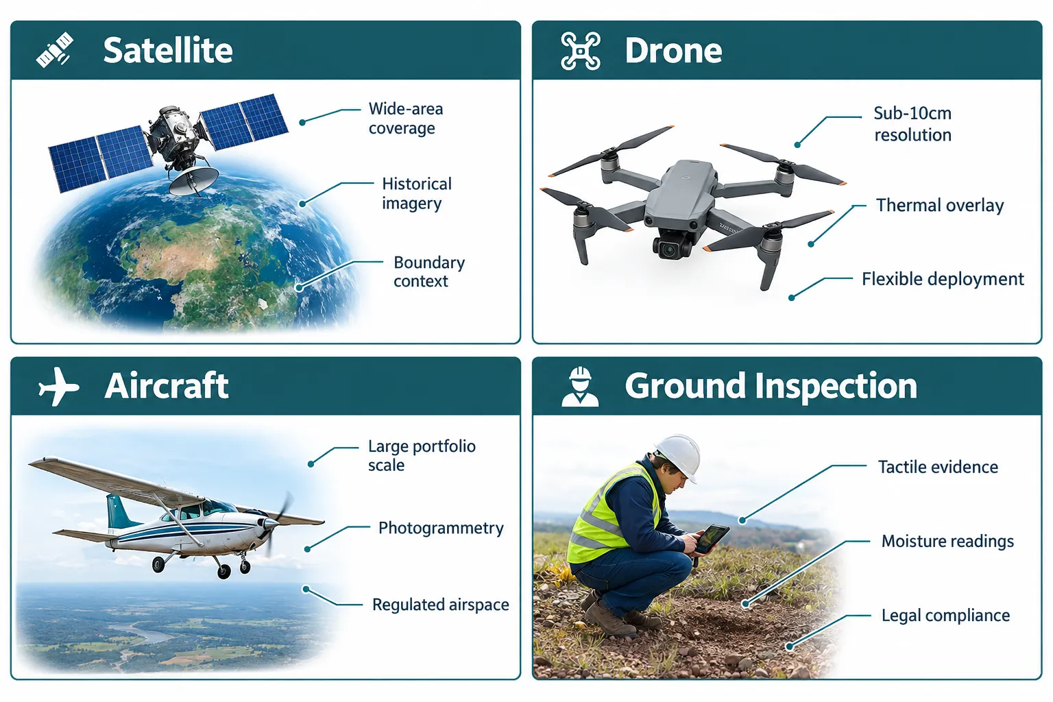
Key platform characteristics at a glance:
| Platform | Typical ground resolution | Best suited for | Main limitation |
|---|---|---|---|
| Commercial satellite | 30 cm, 3 m | Portfolio screening, historical change, boundary context | Cannot resolve fine defects; revisit lag |
| Crewed aircraft | 5-30 cm | Large-scale mapping, photogrammetry | Cost; requires specialist operator |
| Drone (UAV) | 1-10 cm | Individual property defect and damp screening | Regulatory constraints; weather-dependent |
| Ground inspection | N/A | Legal confirmation, moisture readings, structural assessment | Time and access-dependent |
The RICS guidance is explicit that remote data must be geo-referenced accurately, with ground control points used to validate positional accuracy before any measurements or boundary inferences are drawn [4]. Without that calibration step, even high-resolution imagery can mislead rather than inform.
How Satellite Imagery in Property Surveying Supports Boundary and Site Context Work
Boundary disputes are among the most contentious issues in UK residential and commercial property. Satellite imagery in property surveying does not resolve those disputes, it cannot, because legal boundaries are defined by title deeds and Land Registry plans, not by what a sensor records from orbit. What remote imagery does provide is a powerful contextual layer that helps surveyors identify discrepancies worth investigating on the ground.
Ordnance Survey mapping, which underpins the Land Registry's title plans, is itself derived in part from aerial and satellite observation. When a surveyor overlays current high-resolution satellite imagery against OS base data, anomalies become visible: a fence line that has migrated two metres into a neighbour's garden, an extension that appears to breach the building line, or a driveway that encroaches on highway land. These are not legal findings, they are flags that direct the ground inspection and prompt further documentary research.
For anyone navigating the rules around proximity to boundaries, understanding how close you can build to a neighbour's boundary is essential context before commissioning any remote or on-site survey. Satellite imagery can reveal whether a structure appears to sit within the distances that trigger Party Wall Act obligations or planning conditions, but a qualified surveyor must then verify this physically and legally.
Professional note: The Society of Chartered Surveyors Ireland, which follows closely aligned RICS standards, explicitly states that earth observation data should be used to supplement, not replace, conventional ground survey methods when boundary accuracy is critical [9]. This principle applies equally across UK practice.
Common boundary-related uses of satellite and aerial imagery:
- Identifying apparent encroachments or boundary feature migrations over time using historical image archives
- Confirming the presence, absence, or condition of boundary walls, fences, and hedges before a site visit
- Providing context for boundary disputes resolution by establishing a photographic timeline
- Detecting unauthorised structures or extensions that may affect planning compliance
- Supporting expert witness reports where a documented visual record of site conditions at a given date is required, see guidance on what an expert witness does in property and construction
The critical limitation is temporal resolution. Commercial satellite archives may have imagery from several months or even years ago. A boundary feature erected last month will not appear in archived data, which is why satellite evidence must always be cross-referenced with current site inspection findings.
Thermal Imaging, Drones and Defect Screening: Where Remote Evidence Earns Its Keep
If satellite imagery is most useful for boundary context and portfolio-scale screening, drone-mounted sensors, particularly thermal infrared cameras, are where remote sensing in property surveying delivers its most tangible value at the individual property level.
Thermal imaging surveys work by detecting surface temperature differentials. Damp materials retain heat differently from dry ones; missing or degraded insulation creates cold bridges that show as distinct thermal signatures; water ingress at a parapet or flat roof manifests as a cooler zone during the day and a warmer zone at night as moisture releases stored heat. A skilled surveyor interpreting a thermal drone survey can identify candidate areas of concern before setting foot inside the building.
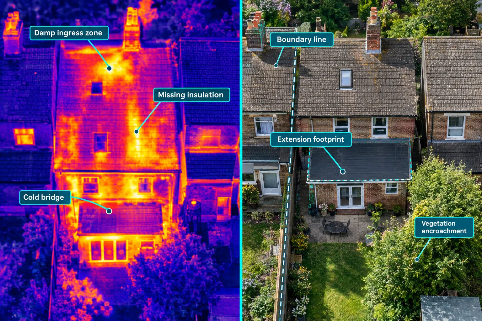
RICS guidance on drone applications and compliance for surveyors acknowledges thermal UAV surveys as an established tool for building condition assessment, noting their particular value for inspecting areas that are difficult or dangerous to access physically, such as high rooflines, industrial roofs, and multi-storey facades [3]. The Landscape Institute's technical information note on drones in practice similarly highlights thermal imaging as one of the primary value-add applications of UAV technology in built environment work [1].
What thermal drone surveys can detect:
- Heat loss through poorly insulated or missing roof coverings
- Moisture retention in flat roofs and parapet walls
- Cold bridges at window and door junctions
- Potential damp ingress zones at chimney stacks, valleys, and gutters
- Air leakage paths in newer construction
What they cannot confirm without follow-up:
- The cause of a thermal anomaly (damp, insulation deficiency, and structural voids can produce similar signatures)
- The severity or extent of damage behind a surface
- Whether a moisture reading is active or historic
This is why thermal drone evidence feeds directly into the decision about whether a specialist damp investigation is warranted. Understanding the complete guide to damp survey costs helps buyers and building owners budget appropriately once remote screening has flagged a concern. Similarly, where timber is implicated, a damp and timber report provides the detailed on-site evidence that remote sensing cannot.
For portfolio-scale work, a housing association managing thousands of units, or a commercial landlord assessing a large estate, aerial thermal surveys of entire streets or blocks can triage which properties need urgent physical inspection, dramatically reducing the cost and time of a full condition survey programme. This application of remote sensing is increasingly mainstream in social housing and commercial property management.
Surveyors working on commercial property will find thermal and multispectral drone surveys particularly useful for large flat-roof assessments, where walking the roof carries both safety risks and the risk of causing further damage to waterproofing membranes.
Combining Remote Evidence with Traditional Surveys: The Professional Standard
The most important principle governing satellite imagery in property surveying is one of integration, not substitution. RICS is unambiguous on this point: remote sensing data forms part of an evidence set and must be combined with appropriate ground-truthing before conclusions are drawn [2][6]. A surveyor who relies solely on satellite or drone imagery to report on damp, defects, or boundaries without physical verification would be acting outside professional standards and would carry significant liability exposure.
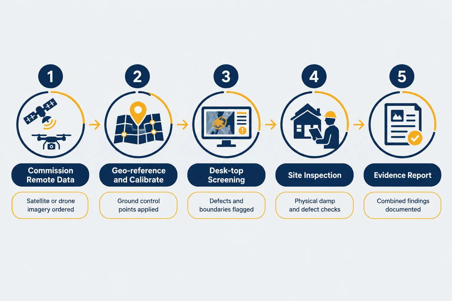
The practical workflow for combining remote and traditional evidence typically follows this sequence:
- Desk-based remote review, Satellite imagery, aerial photography, and available drone data are reviewed alongside OS mapping, Land Registry title plans, planning history, and drainage records. Potential issues are flagged.
- Targeted site inspection, The surveyor attends the property with the remote findings as a structured checklist, directing attention to flagged areas while remaining open to issues not visible from the air.
- Instrument-based verification, Moisture meters, borescopes, thermal imaging guns, and other hand-held instruments confirm or rule out the anomalies identified remotely.
- Integrated reporting, The final report presents remote and on-site evidence together, clearly distinguishing what was observed remotely from what was confirmed physically.
This approach is consistent with the methodology described in the RICS draft guidance note on earth observation and aerial surveys, which emphasises that geo-referencing accuracy and the quality of ground control points must be documented in any professional report that relies on remote data [4].
For buyers commissioning a Level 3 building survey, remote screening can improve the quality of the inspection by ensuring the surveyor arrives with a pre-formed hypothesis about which elements carry the highest risk. It does not replace the physical inspection, it sharpens it.
Where remote evidence adds the most value in a combined approach:
- Roof and chimney condition where access is restricted
- Drainage and surface water flow patterns visible from above
- Vegetation encroachment and root proximity to foundations (relevant to subsidence checks)
- Historical change detection, identifying when an extension was built, or when a boundary feature changed
- Pre-purchase screening for the most common property defects before committing to a full survey
Where remote evidence is insufficient on its own:
- Confirming active damp or measuring moisture content
- Assessing structural integrity of walls, floors, or foundations
- Establishing legal boundaries or resolving title disputes
- Identifying internal defects invisible from outside
- Certifying compliance with building regulations or planning conditions
Regulatory Compliance and the Limits of Remote Sensing in 2026
The use of drones in UK surveying practice is governed by Civil Aviation Authority (CAA) regulations, which set out requirements for operator competency, airspace authorisation, and operational safety. RICS guidance on drones, applications and compliance for surveyors notes that the regulatory landscape continues to evolve, with ongoing focus on urban operations and beyond-visual-line-of-sight (BVLOS) flying [3]. Surveyors commissioning drone surveys must ensure their providers hold the appropriate CAA authorisation and that operations comply with the UK Drone and Model Aircraft Registration and Education Service (DMARES) requirements.
Satellite imagery, by contrast, carries no regulatory burden for the end user, the data is collected by the satellite operator under their own licensing arrangements. However, the quality and currency of commercially available satellite imagery varies significantly between providers, and surveyors must apply professional judgement about whether the resolution and age of available imagery are adequate for the purpose at hand [5].
The RICS earth observation guidance also addresses the cross-jurisdictional adoption of these standards, noting that professional bodies in Ireland and other jurisdictions are aligning with RICS methodology, which signals a broader international consensus around the responsible use of remote evidence in property and land practice [9].
Accuracy requirements for remote evidence in professional reports:
- Positional accuracy must be documented and appropriate for the intended use
- Ground control points should be used to validate geo-referencing where measurements are to be taken from imagery [4]
- The date and source of all remote data must be recorded in the report
- Limitations of the data (resolution, cloud cover, seasonal variation) must be disclosed
Failing to disclose these limitations exposes surveyors to professional indemnity risk and undermines the evidential value of their reports, particularly in litigation contexts where remote data is presented as expert evidence.
Conclusion
Satellite imagery in property surveying, combined with drone-based thermal and visual inspection, represents a genuine advance in the quality and efficiency of evidence available to UK surveyors. Used correctly, as part of a structured, integrated evidence set rather than a standalone substitute for physical inspection, remote sensing sharpens boundary analysis, accelerates damp and defect screening, and produces more defensible survey reports.
The professional standard, as set out in RICS Earth Observation and Aerial Surveys 6th edition, is clear: remote data must be geo-referenced, its limitations disclosed, and its findings verified on the ground before conclusions are drawn. Surveyors who follow this framework can offer clients a materially better service; those who over-rely on remote evidence without physical verification risk both professional censure and client harm.
Actionable next steps for buyers, owners, and advisers:
- When commissioning a building survey, ask your surveyor whether desk-based remote screening forms part of their pre-inspection process.
- If a thermal anomaly or boundary discrepancy is flagged remotely, budget for the appropriate follow-up: a specialist damp survey, a boundary measurement, or a structural inspection.
- Ensure any drone survey provider used by your surveyor holds current CAA authorisation and that their methodology complies with RICS guidance.
- Do not treat satellite or aerial imagery as a substitute for a full property survey, treat it as the first, sharpest lens through which a qualified surveyor begins to understand a property before they arrive at the door.
References
[1] Tin 02 22 Drones In Landscape Practice – landscapewpstorage01.blob.core.windows.net
[2] Earth Observation and Aerial Surveys 6th Edition – rics.org
[3] Drones Applications And Compliance For Surveyors – rics.org
[4] RICS Draft Guidance Note Earth Observation And Aerial Surveys 6th Edition – consultations.rics.org
[5] Earth Observation And Aerial Surveys Reissue Jan 2023 – rics.org
[6] Earth Observation And Aerial Surveys Global Guidance Note 6th Edn – rics.org
[9] Earth Observation And Aerial Surveys (SCSI) – scsi.ie