Global data center construction spending is projected to exceed $500 billion by the end of 2026, driven almost entirely by the insatiable compute demands of artificial intelligence workloads [6]. Behind every server hall that powers large language models and cloud platforms sits a surveying effort of extraordinary precision — one where a floor flatness error measured in millimeters can cascade into millions of dollars of equipment damage or operational downtime. Surveying for Data Centers: Precision Requirements for Hyperscale Computing Sites in 2026 is no longer a niche specialism; it is a critical discipline that shapes whether a hyperscale facility is built on time, on budget, and to the exacting tolerances that modern computing infrastructure demands.
Key Takeaways
- Hyperscale data center construction demands survey tolerances far tighter than standard commercial builds, with floor flatness often specified to within 2 mm across large spans.
- 3D laser scanning and robotic total stations have become standard tools for pre-construction, as-built, and ongoing monitoring surveys at major computing sites.
- Site selection surveys must integrate geotechnical, seismic, utility, and environmental assessments before a single foundation is poured.
- US federal energy reporting requirements are pushing operators to maintain more precise facility metrics, adding a compliance dimension to surveying work.
- Surveyors working on data center projects must understand cooling infrastructure layouts, power distribution pathways, and structural load requirements — not just boundary lines.
Why Hyperscale Computing Sites Demand a New Level of Survey Precision
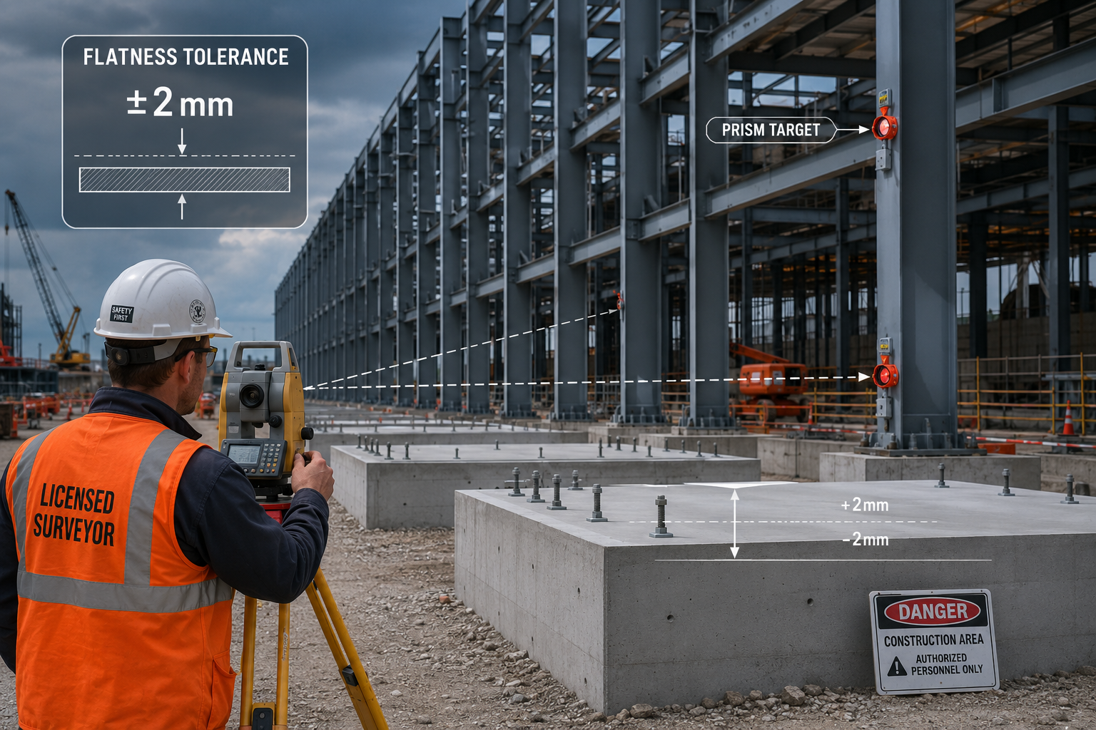
Standard commercial construction tolerances are simply not adequate for hyperscale data centers. A conventional office build might accept floor level variations of 10 mm or more across a bay. A data center housing high-density server racks, robotic storage systems, or precision cooling infrastructure operates under entirely different rules [2].
Floor flatness is one of the most critical metrics. Raised access floor systems — used to route cold air, power cabling, and fiber — require a base slab that is level to within 2 to 3 mm across spans of 30 metres or more. If the slab deviates beyond that tolerance, raised floor tiles rock, airflow is disrupted, and hot-spot cooling failures follow. Robotic material handling systems used in some hyperscale warehousing and colocation facilities are even more demanding, requiring flatness within 1 mm per metre [5].
Structural load mapping is equally important. Modern AI server racks can weigh 25 to 30 kN per rack, compared to 8 to 10 kN for a standard IT rack a decade ago. Surveyors must work alongside structural engineers to verify that slab thickness, reinforcement placement, and subbase preparation all meet design intent before any equipment is installed.
"Precision surveying before construction is not a cost — it is the single most effective form of risk management on a high-value data center project." [2]
Boundary and title surveys also carry elevated stakes. Data center campuses frequently span multiple parcels, involve easements for high-voltage power lines, and require precise setback compliance for cooling tower placement. Errors at this stage can trigger planning delays that cost operators months of lost revenue in a market where AI compute capacity is chronically undersupplied [7].
For professionals who need guidance on choosing the right type of survey for a complex commercial project, reviewing what survey do you need provides a useful framework for matching survey type to project requirements.
Core Survey Types Required for Hyperscale Data Center Projects
Surveying for Data Centers: Precision Requirements for Hyperscale Computing Sites in 2026 encompasses several distinct survey disciplines, each addressing a different phase or risk category of the project lifecycle.
Pre-Construction Site Assessment
Before any planning application is submitted, a comprehensive site assessment survey is required. This goes well beyond a simple topographic survey and typically includes:
| Survey Type | Primary Purpose | Typical Tolerance |
|---|---|---|
| Topographic survey | Grading, drainage, and access planning | 10–50 mm |
| Geotechnical investigation | Bearing capacity, settlement risk | N/A (borehole data) |
| Utility mapping | Underground service avoidance | 100–300 mm |
| Boundary and title survey | Legal compliance, easement identification | 10–25 mm |
| Seismic hazard assessment | Structural design input | N/A (risk classification) |
| Environmental baseline survey | Regulatory compliance | Site-specific |
Geotechnical surveys are particularly important for data centers because of the extraordinary point loads imposed by server racks and the sensitivity of computing equipment to differential settlement. Even minor ground movement after commissioning can break fiber connections, damage raised floor systems, and misalign precision cooling equipment [2].
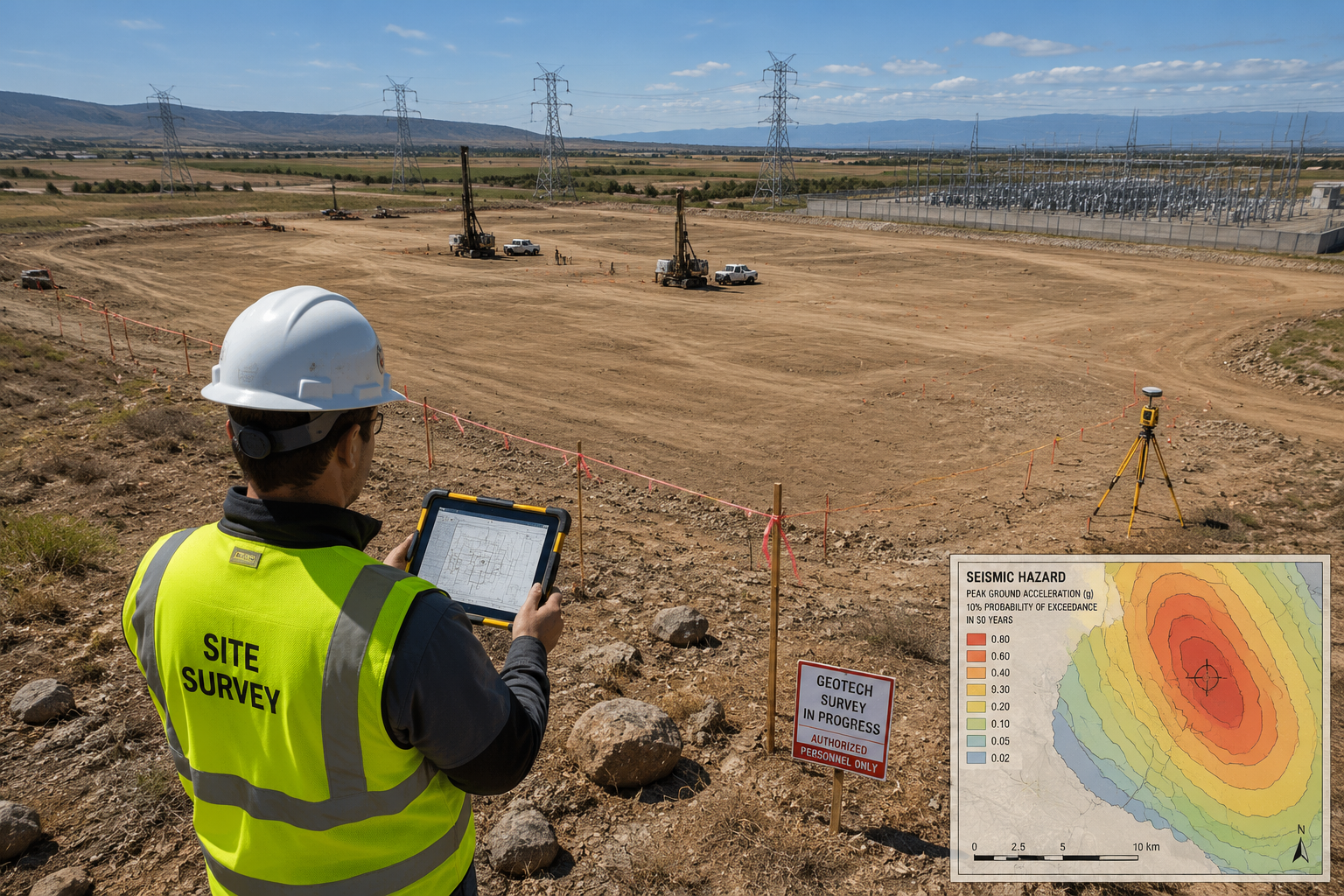
Seismic assessments have grown in importance as operators expand into new geographies to access cheap renewable energy. Sites in Nevada, Arizona, and parts of the UK and Europe that were not previously considered seismically active are now being evaluated with greater scrutiny [4].
As-Built and Structural Surveys
Once construction begins, surveyors are engaged continuously to verify that work matches design intent. This includes:
- Setting-out surveys to position foundations, column grids, and service penetrations
- Slab flatness surveys using digital levels or laser scanning after each concrete pour
- Structural steel surveys to verify column plumb and beam alignment before cladding is installed
- MEP coordination surveys to confirm that mechanical, electrical, and plumbing runs match BIM models
The integration of Building Information Modelling (BIM) with survey data has transformed this phase. Surveyors now deliver georeferenced point clouds that are imported directly into the project BIM, allowing clash detection between structural elements and service routes before physical conflicts occur [5].
For large commercial projects where the condition of the structure at handover is a contractual matter, a schedule of dilapidations approach can also be applied to document baseline conditions before a tenant or operator takes possession of a completed data center shell.
Technology Transforming Data Center Survey Practice in 2026
The technology stack available to surveyors working on hyperscale sites has advanced rapidly. Surveying for Data Centers: Precision Requirements for Hyperscale Computing Sites in 2026 is increasingly defined by the integration of multiple sensor technologies rather than reliance on any single instrument.
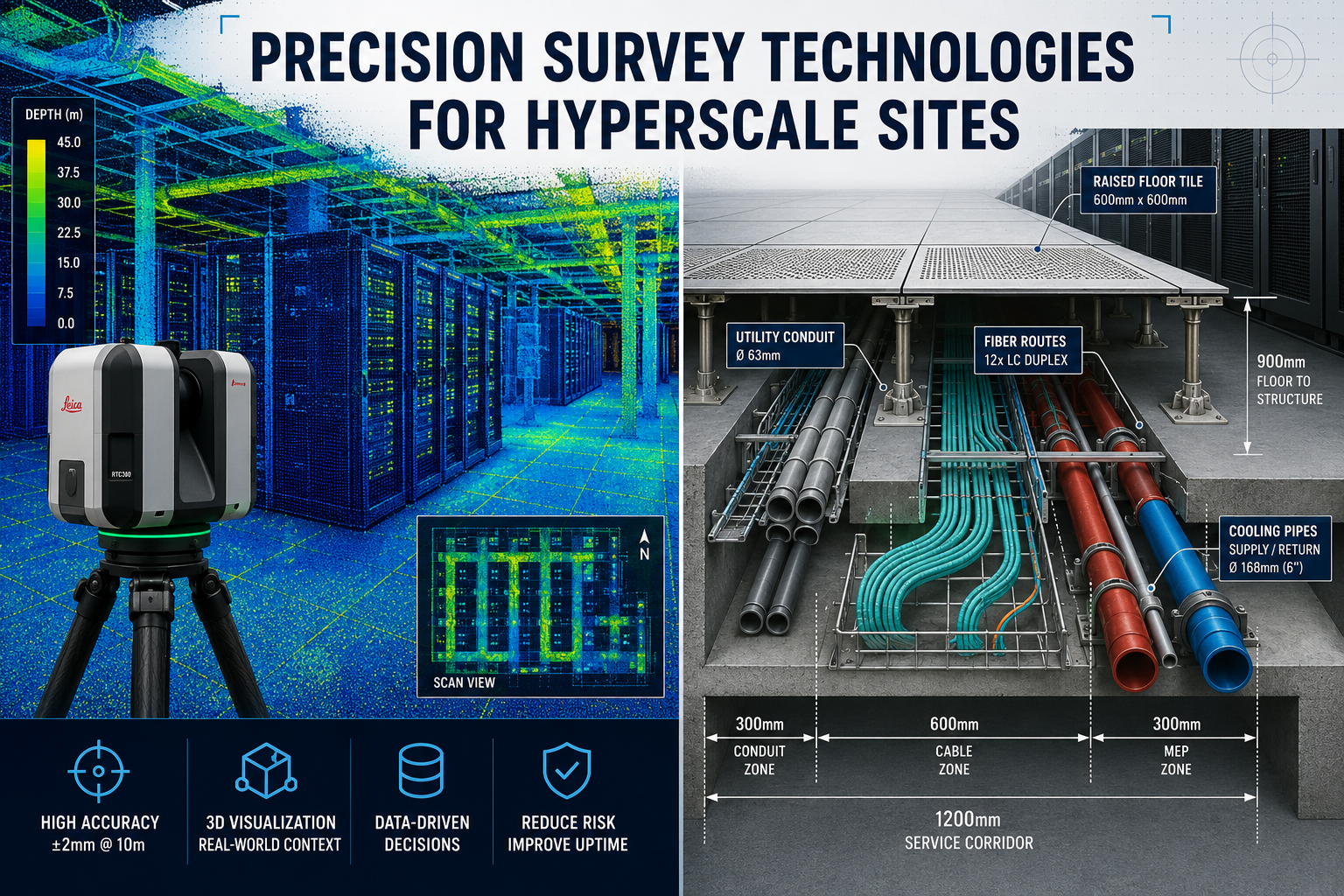
3D Laser Scanning
Terrestrial laser scanners can capture millions of measurement points per second, producing dense point clouds that document the as-built condition of a facility with millimetre-level accuracy [5]. For data center applications, this technology is used to:
- Verify slab flatness across entire floor plates in a single session
- Document the precise position of embedded conduits, anchor bolts, and service penetrations
- Create accurate as-built models for facilities management and future fit-out planning
- Detect structural movement or settlement over time through periodic repeat scans
A full floor plate scan of a 10,000 square metre data center hall can be completed in a single working day, compared to weeks of manual measurement using traditional methods. The resulting data supports not just construction verification but ongoing compliance with increasingly stringent energy and load reporting requirements [1].
Robotic Total Stations and GNSS
Robotic total stations allow a single surveyor to carry out precise setting-out and monitoring work that previously required a two-person team. On large campus sites, Global Navigation Satellite System (GNSS) receivers working in Real-Time Kinematic (RTK) mode provide centimetre-level positioning for boundary surveys, earthworks control, and utility mapping.
The combination of GNSS for large-scale control and laser scanning for detailed as-built capture has become the standard workflow on major hyperscale projects [2].
Drone-Based Photogrammetry
Unmanned aerial vehicles equipped with survey-grade cameras and LiDAR sensors are now routinely used for:
- Volumetric earthworks calculations during site preparation
- Progress monitoring through regular orthophoto and 3D model updates
- Roof and external facade surveys on completed structures
- Thermal imaging to identify cooling inefficiencies or envelope defects post-commissioning
Drone surveys reduce the time and cost of large-area data collection significantly and provide a visual record of construction progress that supports both project management and dispute resolution [10].
For commercial property professionals who need to understand the structural and condition implications of a large building survey, the commercial building surveys London service provides relevant context on how building condition is assessed at handover.
Site Selection: The Survey Work That Happens Before Construction Begins
The site selection process for a hyperscale data center is itself a major surveying exercise. Operators and their advisors evaluate dozens of potential sites before committing to a location, and the quality of survey data at this stage directly determines whether a project proceeds on schedule [7].
Key site selection survey criteria include:
- Power availability: Proximity to high-voltage grid infrastructure, substation capacity, and the feasibility of on-site generation or renewable energy procurement
- Water supply: Availability of water for evaporative cooling, particularly for air-side economizer systems used in hot climates
- Flood risk: Detailed topographic and hydrological surveys to assess 1-in-100 and 1-in-1000 year flood extents
- Ground conditions: Bearing capacity, contamination history, and the presence of underground voids or mining legacy
- Connectivity: Proximity to fiber routes and the cost of dark fiber installation to the nearest internet exchange point
The US federal government's energy load characterisation surveys, which are being phased in for large data centers by late 2026, add a new compliance dimension to site selection. Operators must now be able to demonstrate precise facility metrics — including power usage effectiveness (PUE) and water usage effectiveness (WUE) — which in turn requires accurate survey data on building footprints, mechanical plant areas, and utility connection points [8].
For sites where subsidence is a potential risk — particularly in areas with legacy mining or soft ground — a specialist subsidence survey is an essential part of the due diligence process before committing to land acquisition.
Cooling Infrastructure and the Surveyor's Role
One of the most significant differences between data center surveying and standard commercial construction surveying is the complexity of cooling infrastructure. Modern hyperscale facilities use a combination of:
- Computer Room Air Conditioning (CRAC) units requiring precise floor penetrations and raised floor void management
- Chilled water systems with large-diameter pipe runs that must be coordinated with structural elements
- Cooling towers and dry coolers that impose significant roof or ground-level loads
- Liquid cooling manifolds for high-density AI compute racks, which require millimetre-accurate pipework routing
Surveyors must understand the spatial requirements of these systems to carry out effective setting-out and as-built surveys. A misplaced floor penetration for a chilled water riser can require expensive concrete cutting and delay commissioning by weeks [3].
The trend toward direct liquid cooling (DLC) for AI accelerator clusters is particularly demanding from a survey perspective. DLC systems route coolant directly to server components, requiring leak-free pipework connections at hundreds of individual rack positions. The setting-out tolerance for these systems is typically 5 mm or less, requiring the use of robotic total stations or laser scanning for verification [5].
Legal, Regulatory, and Commercial Considerations
Data center projects involve a complex web of legal and regulatory requirements that have direct implications for survey work.
Planning and zoning surveys must demonstrate compliance with setback requirements, height restrictions, and noise impact zones for cooling equipment. In some jurisdictions, data centers are classified as critical national infrastructure, triggering additional security and resilience requirements that affect site layout and boundary treatment.
Utility easements are a frequent source of dispute on large campus sites. High-voltage power lines, gas mains, and fiber routes may cross the site, and their precise location must be established through utility mapping surveys before any excavation begins. Failure to identify a buried service can result in costly delays and, in the case of high-voltage cables, serious safety incidents [3].
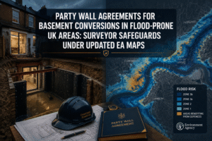
Party wall and boundary matters arise when data center developments are located adjacent to existing buildings or infrastructure. Understanding the legal requirements for party walls is essential for surveyors working on urban or edge-of-town sites where the development boundary is close to neighbouring structures.
For projects where commercial property valuation is required — for example, when a developer is acquiring a site or refinancing a completed facility — working with experienced commercial property surveyors ensures that the valuation reflects the specialist nature of the asset.
The Foley 2026 Data Center Survey Report highlights that land and construction cost inflation, combined with increasing regulatory complexity, has made accurate pre-construction surveying more valuable than ever as a tool for controlling project budgets and timelines [6].
Conclusion: Actionable Steps for Surveyors and Developers
The convergence of AI-driven demand, tightening energy regulations, and increasingly complex building systems has elevated surveying for data centers to a specialist discipline in its own right. The precision requirements for hyperscale computing sites in 2026 are not incremental improvements on standard commercial practice — they represent a fundamentally different level of technical rigour.
For surveyors looking to work in this sector, the following steps are recommended:
- Invest in 3D laser scanning capability. Point cloud data is now a baseline deliverable on hyperscale projects, not an optional extra [5].
- Develop BIM integration skills. The ability to deliver georeferenced survey data directly into a project's BIM environment is a competitive differentiator.
- Understand cooling and power infrastructure. Surveyors who can read mechanical and electrical drawings and understand the spatial implications of cooling systems add significantly more value than those who focus solely on structural elements [3].
- Build knowledge of energy compliance requirements. Federal and national energy reporting frameworks are creating new demand for precise facility metrics that only accurate survey data can support [8].
- Engage early with geotechnical and environmental specialists. The best data center surveys are multidisciplinary from day one, not assembled piecemeal as problems arise [2].
- Stay current with site selection dynamics. Power availability, water access, and seismic risk are reshaping where hyperscale facilities are built, and surveyors who understand these drivers will win more instructions [7].
For developers and operators, the message is equally clear: survey investment at the front end of a data center project is among the highest-return expenditure on the programme. A floor flatness error caught before a concrete pour costs a fraction of the remediation work required after equipment installation. A missed utility easement identified during due diligence avoids a planning refusal that could delay a project by 18 months.
The scale of investment flowing into hyperscale computing infrastructure in 2026 demands nothing less than the highest standard of survey practice — and the profession is rising to meet that challenge [1][9].
References
[1] Data Center Construction Trends – https://cmicglobal.com/resources/article/data-center-construction-trends
[2] Why Precision Surveying And Oversight Matter Before Data Center Construction – https://rtrenergysolutions.com/why-precision-surveying-and-oversight-matter-before-data-center-construction/
[3] Data Center Site Survey Checklist – https://www.process.st/templates/data-center-site-survey-checklist/
[4] 2026 Asce Sustainable Solutions Competition Rules 2026 Rev2 – https://www.asce.org/-/media/asce-images-and-files/communities/students-and-younger-members/documents/2026-asce-sustainable-solutions-competition-rules-2026_rev2.pdf
[5] 3d Scanning Data Centers Guide – https://www.thefuture3d.com/blog-0/2026/3/6/3d-scanning-data-centers-guide/
[6] Foley 2026 Data Center Survey Report – https://www.scribd.com/document/995805227/Foley-2026-Data-Center-Survey-Report
[7] Data Center Site Selection Strategy Update – https://www.nixonpeabody.com/insights/alerts/2026/05/07/data-center-site-selection-strategy-update
[8] Powering Performance Reliability And Compliance In Data Centers – https://www.sgs.com/en-eg/news/2026/04/powering-performance-reliability-and-compliance-in-data-centers
[9] The 8 Data Center Trends That Will Define 2026 – https://arctiq.com/blog/the-8-data-center-trends-that-will-define-2026
[10] How To Build A Data Center Without Going Over Budget In 2025 – https://www.ingenious.build/blog-posts/how-to-build-a-data-center-without-going-over-budget-in-2025